
Gold Bar topographic map
Interactive map
Click on the map to display elevation.
Gold Bar
Gold Bar is known as a white-water rafting destination for those seeking to float the Skykomish River. One of the most popular low elevation hikes in the metro Seattle area, the trail to Wallace Falls, is located on the north margin of the city. More than 160,000 people visit Wallace Falls State Park annually.[15]
About this map
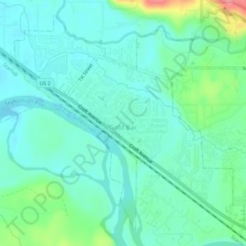
Name: Gold Bar topographic map, elevation, terrain.
Average elevation: 220 ft
Minimum elevation: 151 ft
Maximum elevation: 453 ft
Snohomish County trails, hiking, mountain biking, running and outdoor activities
Other topographic maps
Click on a map to view its topography, its elevation and its terrain.
Bridal Veil Falls-Lower East Cascade
United States > Washington > Snohomish County
Average elevation: 2,037 ft
Glacier Peak
United States > Washington > Snohomish County
Despite its elevation of 10,541 feet (3,213 m), Glacier Peak is a small stratovolcano. Its relatively high summit is a consequence of its location atop a high ridge, but its volcanic portion extends only 1,600–3,200 feet (500–1,000 m) above the underlying ridge. Another Cascade Arc volcano with similar…
Average elevation: 8,714 ft
Whitehorse Mountain
United States > Washington > Snohomish County
Whitehorse Mountain is a peak near the western edge of the North Cascades in Washington state. It is located just southwest of the Sauk River Valley town of Darrington, near the northern boundary of Boulder River Wilderness in Mount Baker-Snoqualmie National Forest. While not of particularly high absolute…
Average elevation: 4,692 ft
Lynnwood
United States > Washington > Snohomish County > Lynnwood > Lynnwood
Average elevation: 367 ft
Mill Creek
United States > Washington > Snohomish County > Mill Creek > Mill Creek
Average elevation: 423 ft