
Make a donation
Gear up for your next adventure:
As an Amazon Associate, this site earns from qualifying purchases at no extra cost to you.
Aral District topographic map
Click on the map to display elevation.
Make a donation
Gear up for your next adventure:
As an Amazon Associate, this site earns from qualifying purchases at no extra cost to you.
About this map
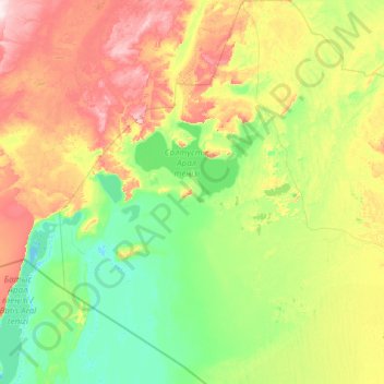
Name: Aral District topographic map, elevation, terrain.
Location: Aral District, Kyzylorda Region, Kazakhstan (44.48071 59.03060 47.82773 63.40709)
Average elevation: 289 ft
Minimum elevation: 85 ft
Maximum elevation: 1,198 ft
Make a donation
Gear up for your next adventure:
As an Amazon Associate, this site earns from qualifying purchases at no extra cost to you.
Other topographic maps
Click on a map to view its topography, its elevation and its terrain.
Lake Kamyslybas
Kazakhstan > Kyzylorda Region > Aral District
Lake Kamyslybas (Kazakh: Қамыстыбас, Qamystybas) is a large saltwater lake in the Kyzylorda Region, Kazakhstan. It has an area of 176 km2, although the water level in the lake often fluctuates. It has a maximum depth of 10 meters with a coastline 116 km long at an elevation of 58 meters above sea…
Average elevation: 236 ft