Geolocate

Roxas topographic map

Click on the map to display elevation.

About this map

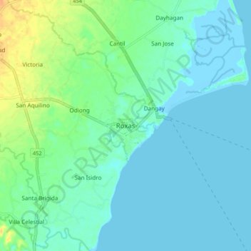
Name: Roxas topographic map, elevation, terrain.

Location: Roxas, Oriental Mindoro, Mimaropa, Philippines (12.55086 121.47702 12.63086 121.55702)

Average elevation: 23 ft

Minimum elevation: -20 ft

Maximum elevation: 98 ft

Other topographic maps

Click on a map to view its topography, its elevation and its terrain.

Inclanay Dam

Philippines > Oriental Mindoro > Inclanay > Pansulan

Average elevation: 95 ft

Bansud River

Philippines > Oriental Mindoro > Conrazon

Average elevation: 1,132 ft

Bongabong River

Philippines > Oriental Mindoro

Average elevation: 1,972 ft

Naujan Lake

Philippines > Oriental Mindoro > Malabo

Average elevation: 151 ft

Masipit

Philippines > Oriental Mindoro > Calapan

Average elevation: 13 ft

Tawiran

Philippines > Oriental Mindoro > Calapan

Average elevation: 20 ft

Lalud

Philippines > Oriental Mindoro > Calapan > Guinobatan

Average elevation: 26 ft

Gear up for your next adventure:

🧢Sun Protection Hats - Wide-brimmed and UPF-rated hats for high-altitude sun safety
🌡️Handheld Weather Meters - Measure wind, temp, and pressure for safe mountain travel
😴Insulated Sleeping Pads - Compact and warm pads for high-elevation camping
⛑️Personal Locator Beacon - Safety beacon for emergencies
🪶Paracord Bracelet - Survival bracelet with built‑in tools

As an Amazon Associate, this site earns from qualifying purchases at no extra cost to you.