
Linn Creek topographic map
Interactive map
Click on the map to display elevation.
Linn Creek
In 1929 it was announced that the Bagnell Dam would be constructed and the town would be flooded, causing controversy among the city's citizens. Almost all of the buildings were demolished, and the city was moved to a higher elevation, losing its designation as the county seat.
About this map
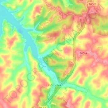
Name: Linn Creek topographic map, elevation, terrain.
Location: Linn Creek, Camden County, Missouri, United States (38.02645 -92.72076 38.07885 -92.68584)
Average elevation: 820 ft
Minimum elevation: 643 ft
Maximum elevation: 981 ft
Camden County trails, hiking, mountain biking, running and outdoor activities
Other topographic maps
Click on a map to view its topography, its elevation and its terrain.