Make a donation
Gear up for your next adventure:
As an Amazon Associate, this site earns from qualifying purchases at no extra cost to you.
Bulphan topographic map
Click on the map to display elevation.
Make a donation
Gear up for your next adventure:
As an Amazon Associate, this site earns from qualifying purchases at no extra cost to you.
About this map
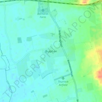
Name: Bulphan topographic map, elevation, terrain.
Location: Bulphan, Thurrock, Essex, England, RM14 3TU, United Kingdom (51.52769 0.34019 51.56769 0.38019)
Average elevation: 33 ft
Minimum elevation: 7 ft
Maximum elevation: 135 ft
Make a donation
Gear up for your next adventure:
As an Amazon Associate, this site earns from qualifying purchases at no extra cost to you.
Other topographic maps
Click on a map to view its topography, its elevation and its terrain.
Make a donation
Gear up for your next adventure:
As an Amazon Associate, this site earns from qualifying purchases at no extra cost to you.
Wivenhoe Woods
United Kingdom > England > Essex > Colchester > Wivenhoe > Rowhedge
Average elevation: 59 ft
Make a donation
Gear up for your next adventure:
As an Amazon Associate, this site earns from qualifying purchases at no extra cost to you.
Make a donation
Gear up for your next adventure:
As an Amazon Associate, this site earns from qualifying purchases at no extra cost to you.
South Woodham Ferrers
United Kingdom > England > Essex > Chelmsford > South Woodham Ferrers
Average elevation: 46 ft
