
Make a donation
Gear up for your next adventure:
As an Amazon Associate, this site earns from qualifying purchases at no extra cost to you.
Yumbo topographic map
Click on the map to display elevation.
Make a donation
Gear up for your next adventure:
As an Amazon Associate, this site earns from qualifying purchases at no extra cost to you.
Yumbo
Yumbo has a relatively dry but extremely foggy and sunless tropical savanna climate (Köppen Aw) not unlike the climate of Bogotá except substantially hotter due to the lower elevation.
Make a donation
Gear up for your next adventure:
As an Amazon Associate, this site earns from qualifying purchases at no extra cost to you.
About this map
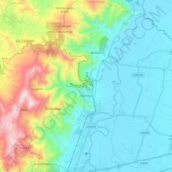
Name: Yumbo topographic map, elevation, terrain.
Location: Yumbo, Sur, Valle del Cauca, RAP Pacífico, 760501, Colombia (3.49025 -76.59781 3.69989 -76.42630)
Average elevation: 4,104 ft
Minimum elevation: 3,074 ft
Maximum elevation: 7,205 ft
Make a donation
Gear up for your next adventure:
As an Amazon Associate, this site earns from qualifying purchases at no extra cost to you.
Other topographic maps
Click on a map to view its topography, its elevation and its terrain.
Make a donation
Gear up for your next adventure:
As an Amazon Associate, this site earns from qualifying purchases at no extra cost to you.
Make a donation
Gear up for your next adventure:
As an Amazon Associate, this site earns from qualifying purchases at no extra cost to you.