Geolocate

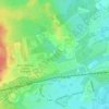
Normandy topographic map

Click on the map to display elevation.

About this map
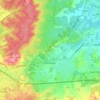
Name: Normandy topographic map, elevation, terrain.

Location: Normandy, Guildford, Surrey, England, United Kingdom (51.23527 -0.71216 51.28878 -0.63036)

Average elevation: 223 ft

Minimum elevation: 102 ft

Maximum elevation: 394 ft

Other topographic maps

Click on a map to view its topography, its elevation and its terrain.
Guildford

United Kingdom > England > Surrey > Guildford

Average elevation: 210 ft

Cooper's Hill

United Kingdom > England > Surrey > Guildford

Average elevation: 187 ft

Fairlands

United Kingdom > England > Surrey > Guildford

Average elevation: 157 ft

Gatwick

United Kingdom > England > Surrey > Guildford

Average elevation: 210 ft

Newlands Corner

United Kingdom > England > Surrey > Guildford > Albury

Average elevation: 397 ft

Merrow Common

United Kingdom > England > Surrey > Guildford > West Clandon

Average elevation: 190 ft

Farley Heath

United Kingdom > England > Surrey > Guildford

Average elevation: 344 ft

Guildford

United Kingdom > England > Surrey > Guildford

Average elevation: 210 ft

Guildford

United Kingdom > England > Surrey > Guildford

Average elevation: 210 ft

Gear up for your next adventure:

🏔️Mountain Trail Maps - High‑detail maps for popular peaks
🦺Reflective Outdoor Gear - Safety gear for low‑light conditions
🎒Hydration Pack - Hands‑free water reservoir for long hikes
🍳Camping Cook Set - Complete cookware for outdoor meals
🦶Carbon Trekking Poles - Reduce knee impact on steep descents with ultra-light poles

As an Amazon Associate, this site earns from qualifying purchases at no extra cost to you.