
Albuquerque topographic map
Click on the map to display elevation.
Albuquerque
Albuquerque features a striking topography characterized by its elevation and diverse geological formations. The city sits at an approximate elevation of 4,900 feet (1,500 meters) near the Rio Grande, rising dramatically to over 6,700 feet (2,000 meters) in the foothills of the nearby Sandia Mountains. These mountains create a striking eastern backdrop, with the highest point in the region reaching about 10,678 feet (3,255 meters) at Sandia Crest. The landscape also includes expansive mesas to the west, such as the West Mesa and the Petroglyph National Monument, which are renowned for their volcanic features and ancient rock art. This unique terrain offers a mix of arid desert conditions and mountainous ecosystems, contributing to the area's rich biodiversity and scenic beauty.
About this map
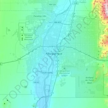
Name: Albuquerque topographic map, elevation, terrain.
Location: Albuquerque, Bernalillo County, New Mexico, United States (34.94709 -106.88215 35.21820 -106.47118)
Average elevation: 5,535 ft
Minimum elevation: 4,888 ft
Maximum elevation: 10,646 ft
Bernalillo County trails, hiking, mountain biking, running and outdoor activities
Other topographic maps
Click on a map to view its topography, its elevation and its terrain.
Albuquerque
United States > New Mexico > Bernalillo County
Albuquerque is located in north-central New Mexico. To its east are the Sandia–Manzano Mountains. The Rio Grande flows north to south through its center, while the West Mesa and Petroglyph National Monument make up the western part of the city. Albuquerque has one of the highest elevations of any major city…
Average elevation: 5,482 ft
Sandia Mountains Historical Marker
United States > New Mexico > Bernalillo County
Average elevation: 9,639 ft
Eastrange-Piedra Vista
United States > New Mexico > Bernalillo County > Albuquerque
Average elevation: 6,033 ft
Sandia Crest
United States > New Mexico > Bernalillo County
The Sandias are the highest range in the immediate vicinity, and are well-separated from the higher Sangre de Cristo Mountains. This gives Sandia Crest a relatively high topographic prominence of 4,098 ft (1,249 m). Lying to the east and northeast of the Sandias are two smaller ranges, the Ortiz Mountains and…
Average elevation: 9,596 ft
Albuquerque
United States > New Mexico > Bernalillo County
Albuquerque is located in north-central New Mexico. To its east are the Sandia–Manzano Mountains. The Rio Grande flows north to south through its center, while the West Mesa and Petroglyph National Monument make up the western part of the city. Albuquerque has one of the highest elevations of any major city…
Average elevation: 5,482 ft
Sandia Heights
United States > New Mexico > Bernalillo County > Albuquerque
Average elevation: 6,227 ft
Vista Del Mundo
United States > New Mexico > Bernalillo County > Albuquerque
Average elevation: 6,243 ft
Albuquerque
United States > New Mexico > Bernalillo County
Albuquerque is located in north-central New Mexico. To its east are the Sandia–Manzano Mountains. The Rio Grande flows north to south through its center, while the West Mesa and Petroglyph National Monument make up the western part of the city. Albuquerque has one of the highest elevations of any major city…
Average elevation: 5,482 ft
Winterwood Park (HOA)
United States > New Mexico > Bernalillo County > Albuquerque
Average elevation: 5,807 ft
Monte Largo Hills
United States > New Mexico > Bernalillo County > Albuquerque
Average elevation: 5,961 ft
Embudo Canyon
United States > New Mexico > Bernalillo County > Albuquerque
Average elevation: 6,096 ft
Glenwood Hills
United States > New Mexico > Bernalillo County > Albuquerque
Average elevation: 6,355 ft
Joe M. Lucero Hillside
United States > New Mexico > Bernalillo County > Albuquerque
Average elevation: 5,371 ft