
Make a donation
Gear up for your next adventure:
As an Amazon Associate, this site earns from qualifying purchases at no extra cost to you.
Lower Himalayan Range topographic map
Click on the map to display elevation.
Make a donation
Gear up for your next adventure:
As an Amazon Associate, this site earns from qualifying purchases at no extra cost to you.
About this map
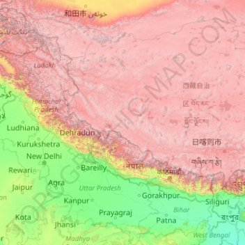
Name: Lower Himalayan Range topographic map, elevation, terrain.
Location: Lower Himalayan Range, Nepal (27.68355 76.04732 33.94340 91.88963)
Average elevation: 9,688 ft
Minimum elevation: 7 ft
Maximum elevation: 26,562 ft
Make a donation
Gear up for your next adventure:
As an Amazon Associate, this site earns from qualifying purchases at no extra cost to you.
Other topographic maps
Click on a map to view its topography, its elevation and its terrain.
Kathmandu
Nepal > Bagmati Province > Kathmandu
Kathmandu is located at an elevation of approximately 4,600 feet (1,400 meters) within the Kathmandu Valley. This valley is characterized by a bowl-like topography, encircled by the lower Himalayan ranges, which rise sharply in the north, culminating in peaks that exceed 24,000 feet (7,300 meters). The…
Average elevation: 5,046 ft
Himalayas
Nepal > Koshi Province > Solukhumbu
The Himalayas present a dramatic and varied topography characterized by towering peaks, deep valleys, and extensive glaciers. This majestic mountain range features some of the highest elevations on Earth, including Mount Everest, which rises to 29,035 feet. The terrain is marked by steep, jagged ridges and…
Average elevation: 24,787 ft
Mount Everest
Nepal > Koshi Province > Solukhumbu
Mount Everest (Nepali: सगरमाथा, romanized: Sagarmāthā; Standard Tibetan: ཇོ་མོ་གླང་མ, romanized: Chomolungma; Chinese: 珠穆朗玛峰; pinyin: Zhūmùlǎngmǎ Fēng) is Earth's highest mountain above sea level, located in the Mahalangur Himal sub-range of the Himalayas.…
Average elevation: 25,745 ft
Morang
Morang District (Nepali: मोरङ जिल्ला listen) is located in Koshi Province in eastern Nepal. It is an Outer Terai district. It borders Jhapa to the east, Dhankuta and Panchthar to the north, Sunsari to the west, and Bihar, India, to the south. Morang has one metropolitan city (Biratnagar),…
Average elevation: 860 ft
Make a donation
Gear up for your next adventure:
As an Amazon Associate, this site earns from qualifying purchases at no extra cost to you.
Bagamati Province
Bagmati Province has an area of 20,300 km2 which is about 13.79% of the total area of Nepal. The elevation of the province ranges from 141 m at Golaghat in Chitwan District to 7,422m at Ganesh Himal. The province has an altitude low enough to support deciduous, coniferous, and alpine forests and woodlands.…
Average elevation: 6,946 ft
Mount Everest
Nepal > Koshi Province > Solukhumbu
Mount Everest (Nepali: सगरमाथा, romanized: Sagarmāthā; Standard Tibetan: ཇོ་མོ་གླང་མ, romanized: Chomolungma; Chinese: 珠穆朗玛峰; pinyin: Zhūmùlǎngmǎ Fēng) is Earth's highest mountain above sea level, located in the Mahalangur Himal sub-range of the Himalayas.…
Average elevation: 25,745 ft
Himalayas
Nepal > Koshi Province > Solukhumbu
The Himalayas, or Himalaya (/ˌhɪməˈleɪ.ə, hɪˈmɑːləjə/; Sanskrit: [ɦɪmaːlɐjɐ]; from Sanskrit himá 'snow, frost', and ā-laya 'dwelling, abode'), is a mountain range in Asia, separating the plains of the Indian subcontinent from the Tibetan Plateau. The range has some of the planet's highest…
Average elevation: 24,787 ft
Make a donation
Gear up for your next adventure:
As an Amazon Associate, this site earns from qualifying purchases at no extra cost to you.
Dhankuta
Dhankuta is a mid-hill district of eastern hill region of Nepal. It is situated between 26°53' to 27°19' north latitude and 87°8' to 88°33' east longitude. Total area of the district is 888.7 square kilometres (343.1 sq mi) and it is located at 243 metres (9,600 in) to 629 metres (24,800 in) of elevation…
Average elevation: 3,602 ft
Syangja
Syangja District lies in the hilly region, with altitudes ranging from approximately 300 meters along the banks of the Kaligandaki River to about 3520 metersPanchase above sea level. It is situated at a latitude of 28°4'60" North and a longitude of 83°52'0" East.
Average elevation: 3,320 ft
Make a donation
Gear up for your next adventure:
As an Amazon Associate, this site earns from qualifying purchases at no extra cost to you.
Mount Everest
Nepal > Eastern Development Region > Khumjung
Mount Everest (Chinese: 珠穆朗玛 Zhūmùlǎngmǎ; Nepali: सगरमाथा Sagarmāthā; Tibetan: Chomolungma ཇོ་མོ་གླང་མ) is Earth's highest mountain above sea level, located in the Mahalangur Himal sub-range of the Himalayas. The China–Nepal border runs across its summit…
Average elevation: 25,725 ft
Mount Everest
Nepal > Koshi Province > Solukhumbu
Mount Everest is Earth's highest mountain above sea level, located in the Mahalangur Himal sub-range of the Himalayas. The China–Nepal border runs across its summit point. Its elevation (snow height) of 8,848.86 m (29,031 ft 8+1⁄2 in) was most recently established in 2020 by the Chinese and Nepali authorities.
Average elevation: 25,745 ft
Make a donation
Gear up for your next adventure:
As an Amazon Associate, this site earns from qualifying purchases at no extra cost to you.
Kathmandu Valley
Kathmandu valley is bowl-shaped. Its central lower part stands at 1,425 metres (4,675 ft) above sea level. Kathmandu valley is surrounded by four mountain ranges: Shivapuri hills (at an elevation of 2,732 metres or 8,963 feet), Phulchowki (2,695 metres or 8,842 feet), Nagarjun (2,095 metres or 6,873 feet) and…
Average elevation: 5,233 ft
Make a donation
Gear up for your next adventure:
As an Amazon Associate, this site earns from qualifying purchases at no extra cost to you.
Pokhara
Nepal > Gandaki Province > Kaski
Pokhara (Nepali: पोखरा, Nepali pronunciation: [ˈpokʰʌɾa]) is a metropolitan city in Nepal, which serves as the capital of Gandaki Province. It is the second most populous city of Nepal after Kathmandu, with 518,452 inhabitants living in 101,669 households in 2021. It is the country's largest…
Average elevation: 3,947 ft
Make a donation
Gear up for your next adventure:
As an Amazon Associate, this site earns from qualifying purchases at no extra cost to you.
Khotang
Geographically, Khotang is a hilly district of Eastern Nepal. It lies on the coordinates of 260° 50" N to 270° 28" N latitude and 860° 26" E to 860° 58" E longitude. Coordinates of the center is 27° 11' 60.00" N and 86° 46' 59.99" E. Total area of the district is 1,591 square kilometres (614 sq mi). The…
Average elevation: 4,321 ft
Make a donation
Gear up for your next adventure:
As an Amazon Associate, this site earns from qualifying purchases at no extra cost to you.
Koshi Province
Koshi Pradesh covers an area of 25,905 km2. The province has three-fold geographical division: Himalayan in the north, Hilly in the middle and Terai in the southern part of Nepal, varying between an altitude of 70 m and 8,848 m. Terai, extended from east to west, is made up of alluvial soil. To the west of…
Average elevation: 7,244 ft
Darchula District (Nepal)
Nepal > Sudurpashchim Province
The Himalayan region between two rivers Kali River to Seti River calls Gurans Himal. Darchula district falls in the Gurans Himal zone. Api Himal (7,132 metres (23,399 ft)) and Jethi Bahurani (6,850 metres (22,470 ft)) are main mountain peaks of the area. There is a protected area named Api Nampa Conservation…
Average elevation: 11,112 ft
Make a donation
Gear up for your next adventure:
As an Amazon Associate, this site earns from qualifying purchases at no extra cost to you.
Mount Everest
Nepal > Koshi Province > Solukhumbu
Mount Everest (Nepali: सगरमाथा, romanized: Sagarmāthā; Tibetan: Chomolungma ཇོ་མོ་གླང་མ; Chinese: 珠穆朗玛峰; pinyin: Zhūmùlǎngmǎ Fēng) is Earth's highest mountain above sea level, located in the Mahalangur Himal sub-range of the Himalayas. The China–Nepal…
Average elevation: 25,755 ft
Chitwan National Park
Chitwan National Park is the first national park of Nepal. It was established in 1973 as the Royal Chitwan National Park and was granted the status of a World Heritage Site in 1984. It covers an area of 952.63 km2 (367.81 sq mi) in the subtropical Inner Terai lowlands of south-central Nepal in Nawalpur,…
Average elevation: 1,257 ft
Make a donation
Gear up for your next adventure:
As an Amazon Associate, this site earns from qualifying purchases at no extra cost to you.
Make a donation
Gear up for your next adventure:
As an Amazon Associate, this site earns from qualifying purchases at no extra cost to you.
Kaski
The district, with Pokhara as its district headquarter, covers an area of 2,017 square km and had a total population of 492,098 according to 2011 Census. This district lies at the centroid point of the country. The altitude of Kaski district ranges from 450 meters the lowest land to 8091 meters the highest…
Average elevation: 8,415 ft
Nuwakot
Agriculture remains the dominant livelihood, with terrace farming widely practiced. Crops such as rice, maize, millet, and mustard are cultivated based on elevation and seasonal rainfall patterns. Livestock rearing is also integrated into household economies.
Average elevation: 5,922 ft
Ghorahi
Nepal > Lumbini Province > Dang
Ghorahi is the main town of the Rapti Zone and also the headquarters of the Dang district. It is located at an elevation of 2,300 feet (700 m) in the Mahabharat-Chure hill region.
Average elevation: 2,838 ft
Make a donation
Gear up for your next adventure:
As an Amazon Associate, this site earns from qualifying purchases at no extra cost to you.
Arghakhanchi
Arghakhanchi lies between 27'45"N and 28'6"N latitude, and 80'45"E to 83'23"E longitude. It covers 1,193 km2. The altitude of the district varies from 305 to 2515 meter above the sea level. 68% of the district is in the mountainous Mahabharat Range and the rest is in the Siwalik Hills. Elevations range from…
Average elevation: 3,156 ft
Make a donation
Gear up for your next adventure:
As an Amazon Associate, this site earns from qualifying purchases at no extra cost to you.
Bajhang
Nepal > Sudurpashchim Province
The district is surrounded by Bajura and Humla in the East, Baitadi and Darchula in the West, Humla in the North and Doti and Achham in the South. The district is located between 29°29' and 30°09' north longitude, and 80°46' and 81°34 east latitude. The elevation of the district from sea level is 900…
Average elevation: 11,499 ft
Mount Everest
Nepal > Koshi Province > Solukhumbu
Mount Everest (Nepali: सगरमाथा, romanized: Sagarmāthā; Standard Tibetan: ཇོ་མོ་གླང་མ, romanized: Chomolungma; Chinese: 珠穆朗玛峰; pinyin: Zhūmùlǎngmǎ Fēng) is Earth's highest mountain above sea level, located in the Mahalangur Himal sub-range of the Himalayas.…
Average elevation: 25,745 ft
Make a donation
Gear up for your next adventure:
As an Amazon Associate, this site earns from qualifying purchases at no extra cost to you.
Solukhumbu
Solukhumbu is a Himalayan district of Province No. 1 of Nepal, situated on the north-west corner of province. It is one out of 3 Himalayan districts of Province No. 1. Total area of district is 3,312 square kilometres (1,279 sq mi). It is situated between Lat. 27°20'39" to 28°6'24" North and Long. 86°0'21"…
Average elevation: 13,110 ft
Dolakha
Dolakha is also home to another holy temple - Kalinchowk Bhagawati. It is situated in high mountains at an altitude of about 3842m and the pilgrims are known to walk a long and dangerous route via the mountains to the temple. But, in 2018 the government started a new cable car service for the comfort of the…
Average elevation: 11,325 ft
Make a donation
Gear up for your next adventure:
As an Amazon Associate, this site earns from qualifying purchases at no extra cost to you.
Syangja
Syangja District (Nepali: स्याङ्जा जिल्ला; Listen (help·info)), a part of Gandaki Province, is one of the seventy-seven districts of Nepal. The district, with Syangja bazaar (a small town) as its district headquarters, covers an area of 1,164 km2 (449 sq mi) and had a population of…
Average elevation: 3,320 ft
Make a donation
Gear up for your next adventure:
As an Amazon Associate, this site earns from qualifying purchases at no extra cost to you.
Gorak Shep
Nepal > Koshi Province > Solukhumbu
Gorak Shep or Gorakshep (Nepali: गोरकशेप) is a small settlement that sits on the edge of a frozen lakebed covered with sand in Nepal with the same name. It is found at an elevation of 5,164 metres (16,942 ft) elevation, near Mount Everest. The village is not inhabited year-round.
Average elevation: 17,241 ft
Taplejung
Geographically Taplejung is a mountainous district where the world's third highest peak Kanchenjunga (8586 m) is located. It is situated at elevation ranging from 670 metres (2,200 ft) to 8,586 metres (28,169 ft) from sea level.
Average elevation: 12,776 ft
Make a donation
Gear up for your next adventure:
As an Amazon Associate, this site earns from qualifying purchases at no extra cost to you.
Sarangkot
Nepal > Gandaki Province > Kaski > Pokhara
The Ward is located on Sarangkot, a hill on the western side of Pokhara with an altitude of 1600m. Sarangkot is known for its panoramic Himalayan views of Dhaulagiri, Annapurna and Manaslu. It also provides an expansive view of the city of Pokhara, from the extreme north to the south including Phewa Lake.…
Average elevation: 3,737 ft
Kathmandu Metropolitan City
Nepal > Bagamati Province > Kathmandu
Kathmandu, officially the Kathmandu Metropolitan City, is the seat of federal government and the most populous city in Nepal. As of the 2021 Nepal census, there were 845,767 inhabitants living in 105,649 households and approximately 4 million people in its surrounding agglomeration. It is located in the…
Average elevation: 4,354 ft
Make a donation
Gear up for your next adventure:
As an Amazon Associate, this site earns from qualifying purchases at no extra cost to you.
Manaslu
Nepal > Gandaki Province > Gorkha
The Manaslu region offers a variety of trekking options. The popular Manaslu trekking route of 177 kilometres (110 mi) skirts the Manaslu massif over the pass down to Annapurna. The Nepalese Government only permitted trekking on this circuit in 1991. The trekking trail follows an ancient salt-trading route…
Average elevation: 23,192 ft
Pokhara
Nepal > Gandaki Province > Kaski
Pokhara (Nepali: पोखरा, Nepali pronunciation: [ˈpokʰʌɾa]) is a metropolitan city in Nepal, which serves as the capital of Gandaki Province. It is the second most populous city of Nepal after Kathmandu, with 518,452 inhabitants living in 101,669 households in 2021. It is the country's largest…
Average elevation: 3,947 ft
Mustang
The district is a part of Gandaki Province in northern Nepal, straddles the Himalayas and extends northward onto the Tibetan Plateau. The district is one of the remotest areas in Nepal and is second in terms of the sparsity of population. The elevation ranges from 1,372 to 8,167 meters (Mount Dhaulagiri, the…
Average elevation: 16,201 ft
Make a donation
Gear up for your next adventure:
As an Amazon Associate, this site earns from qualifying purchases at no extra cost to you.
Siraha
Nepal > Madhesh Province > Siraha
Siraha (Nepali: सिराहा, sirāhā) is the headquarters and municipality of Siraha District, a part of Madhesh Province, Nepal. Siraha had a population of 28,442 according to the census of 2011. and a population of 82,531 as of 2015. The current population of Siraha municipality as of census 2022, is…
Average elevation: 256 ft
Make a donation
Gear up for your next adventure:
As an Amazon Associate, this site earns from qualifying purchases at no extra cost to you.
Kathmandu Valley
Nepal > Bagamati Province > Lalitpur
Kathmandu Valley is bowl-shaped. Its central lower part stands at 1,425 metres (4,675 ft). Kathmandu Valley is surrounded by five mountain ranges: Shivapuri hills (at an elevation of 2,732 metres (8,963 ft)), Phulchowki (2,762 metres or 9,062 feet), Nagarjun (2,128 metres or 6,982 feet), Champadevi (2,278…
Average elevation: 5,233 ft
Pokhara
Pokhara is in the northwestern corner of the Pokhara Valley, which is a widening of the Seti Gandaki valley that lies in the region (Pahad) of the Himalayas. In this region the mountains rise very quickly, and within 30 kilometres (19 miles), the elevation rises from 1,000 to 7,500 metres (3,300 to 24,600…
Average elevation: 4,009 ft
Nagarkot
Nepal > Bagmati Province > Kavrepalanchok
Nagarkot (Nepali: नगरकोट) is a former Village Development Committee located 32 km east of Kathmandu, Nepal in Bhaktapur District in Bagmati Province and as of 2015 part of Nagarkot Municipality. At the time of the 2011 census it had a population of 4,571 and had 973 houses in it. At an elevation of…
Average elevation: 5,509 ft
Make a donation
Gear up for your next adventure:
As an Amazon Associate, this site earns from qualifying purchases at no extra cost to you.
Sudurpashchim Pradesh
Surma Sarovar is one of the hidden gems in the Sudurpaschim region. Located at an altitude of 4,300 metres, the trail to get there is not easy. walk past high ridges that get to by crossing passes and also get to walk past small lakes and ponds along with meadows with mountains like Jethi Bahurani. The lake is…
Average elevation: 6,165 ft
Make a donation
Gear up for your next adventure:
As an Amazon Associate, this site earns from qualifying purchases at no extra cost to you.
Mount Everest
Nepal > Koshi Province > Solukhumbu
Mount Everest (Nepali: सगरमाथा, romanized: Sagarmāthā; Standard Tibetan: ཇོ་མོ་གླང་མ, romanized: Chomolungma; Chinese: 珠穆朗玛峰; pinyin: Zhūmùlǎngmǎ Fēng) is Earth's highest mountain above sea level, located in the Mahalangur Himal sub-range of the Himalayas.…
Average elevation: 25,745 ft
Make a donation
Gear up for your next adventure:
As an Amazon Associate, this site earns from qualifying purchases at no extra cost to you.
Mera Peak
Nepal > Koshi Province > Solukhumbu
In September 2017, Hari Budha Magar summited Mera Peak, becoming the first double above-knee amputee to climb a mountain over 6,000m in altitude.
Average elevation: 18,730 ft
Make a donation
Gear up for your next adventure:
As an Amazon Associate, this site earns from qualifying purchases at no extra cost to you.
Pokhara
Nepal > Gandaki Province > Kaski
Pokhara (Nepali: पोखरा, Nepali pronunciation: [ˈpokʰʌɾa]) is a metropolitan city in Nepal, which serves as the capital of Gandaki Province. It is the second most populous city of Nepal after Kathmandu, with 518,452 inhabitants living in 101,669 households in 2021. It is the country's largest…
Average elevation: 3,947 ft
Kathmandu Metropolitan City
Nepal > Bagamati Province > Kathmandu
Kathmandu (Nepali: [ˌkaʈʰmaɳˈɖu]) is the capital and largest city of Nepal, situated in the central part of the country within the Kathmandu Valley. As per the 2021 Nepal census, it has a population of 845,767 residing in 105,649 households, with approximately 4 million people in the surrounding…
Average elevation: 4,354 ft
Make a donation
Gear up for your next adventure:
As an Amazon Associate, this site earns from qualifying purchases at no extra cost to you.
Rukum West
Elevation ranges from below 800 meters along the Bheri and its lowest tributaries to about 6,000 meters in the Dhaulagiris with a range of climates from sub-tropical to perpetual snow and ice. Agricultural use ranges from irrigated rice cultivation through upland cultivation of maize, barley, wheat, potatoes…
Average elevation: 7,159 ft
Dhankuta
Dhankuta is a mid-hill district of eastern hill region of Nepal. It is situated between 26°53' to 27°19' north latitude and 87°8' to 88°33' east longitude. Total area of the district is 888.7 square kilometres (343.1 sq mi) and it is located at 243 metres (9,600 in) to 629 metres (24,800 in) of elevation…
Average elevation: 3,602 ft
Bagmati Province
Bagmati Province has an area of 20,300 km2 which is about 13.79% of the total area of Nepal. The elevation of the province ranges from 141 m at Golaghat in Chitwan District to 7,422m at Ganesh Himal. The province has an altitude low enough to support deciduous, coniferous, and alpine forests and woodlands.…
Average elevation: 7,329 ft
Chitwan
Chitwan is known for Taas (Nepali: तास), a spicy fried goat meat dish served with bhuja or cheura. Momo, Bhuteko Bhat (fried rice), and sukuti are other popular dishes. Dal bhat (steamed rice and lentils), is the staple food of the area, though meat and dairy products are also consumed. Other popular…
Average elevation: 1,539 ft
Make a donation
Gear up for your next adventure:
As an Amazon Associate, this site earns from qualifying purchases at no extra cost to you.