
Freyung topographic map
Click on the map to display elevation.
About this map
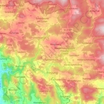
Name: Freyung topographic map, elevation, terrain.
Average elevation: 2,280 ft
Minimum elevation: 1,280 ft
Maximum elevation: 3,028 ft
Other topographic maps
Click on a map to view its topography, its elevation and its terrain.
Stocking
Deutschland > Bayern > Landkreis Freyung-Grafenau > Waldkirchen > Stocking
Average elevation: 2,133 ft
Brotjacklriegel
Deutschland > Bayern > Landkreis Freyung-Grafenau > Schöfweg
Der Brotjacklriegel ist – von der Donau aus gesehen – mit seinen 1011 m ü. NHN Höhe der erste größere Berg im Bayerischen Wald. Der Berg liegt im Landkreis Freyung-Grafenau und stellt ein Wahrzeichen der Region Sonnenwald mit den Gemeinden Schöfweg, Zenting, Innernzell, Grattersdorf und dem Markt…
Average elevation: 2,631 ft
Pittersberg
Deutschland > Bayern > Landkreis Freyung-Grafenau > Freyung > Grillaberg
Average elevation: 2,175 ft
Reichermühle
Deutschland > Bayern > Landkreis Freyung-Grafenau > Reichling
Average elevation: 2,051 ft
Kricklsäge
Deutschland > Bayern > Landkreis Freyung-Grafenau > Philippsreut
Average elevation: 3,159 ft
Hörmannsberg
Deutschland > Bayern > Landkreis Freyung-Grafenau > Grafenau > Heinrichsreit
Average elevation: 2,011 ft
Heinrichsreit
Deutschland > Bayern > Landkreis Freyung-Grafenau > Grafenau
Average elevation: 1,873 ft
Sankt Oswald
Deutschland > Bayern > Landkreis Freyung-Grafenau > Sankt Oswald-Riedlhütte
Average elevation: 2,398 ft
Kaltenberg
Deutschland > Bayern > Landkreis Freyung-Grafenau > Grafenau > Großarmschlag
Average elevation: 2,244 ft
Marchetsreut
Deutschland > Bayern > Landkreis Freyung-Grafenau > Perlesreut
Average elevation: 1,545 ft
Mitternachmühle
Deutschland > Bayern > Landkreis Freyung-Grafenau > Schönberg > Mitternach
Average elevation: 1,631 ft
Lusen
Deutschland > Bayern > Landkreis Freyung-Grafenau > Neuschönau
Der Lusen (tschechisch Luzný) ist mit seiner Höhe von 1373 m ü. NHN nach dem Großen Arber, Großen Rachel, Kleinen Rachel und Kleinen Arber der fünfthöchste Berg im Bayerischen Wald / Böhmerwald. Er liegt wie auch der Rachel und der Große Falkenstein im Nationalpark Bayerischer Wald dicht an der Grenze…
Average elevation: 3,970 ft
Frischeck
Deutschland > Bayern > Landkreis Freyung-Grafenau > Waldkirchen > Ratzing
Average elevation: 2,008 ft
Stadl
Deutschland > Bayern > Landkreis Freyung-Grafenau > Waldkirchen > Auerbach
Average elevation: 1,900 ft
Traxing
Deutschland > Bayern > Landkreis Freyung-Grafenau > Waldkirchen > Ratzing
Average elevation: 1,860 ft
Geyersberg
Deutschland > Bayern > Landkreis Freyung-Grafenau > Freyung
Im Bereich der Ortslage befand sich ursprünglich mit dem Burgstall Geyersberg eine abgegangene mittelalterliche Höhenburg, die Sitz der Passauer Bischöfe war und sich in der Gegenwart unter Bodendenkmalschutz befindet.
Average elevation: 2,034 ft
Klingenbrunn
Deutschland > Bayern > Landkreis Freyung-Grafenau
Das etwa 950 Einwohner zählende Pfarrdorf liegt in einer Höhenlage von 820 Metern an der Straße zwischen Frauenau und Spiegelau.
Average elevation: 2,575 ft
Großarmschlag
Deutschland > Bayern > Landkreis Freyung-Grafenau > Grafenau
Average elevation: 2,192 ft
Holzfreyung
Deutschland > Bayern > Landkreis Freyung-Grafenau > Waldkirchen
Average elevation: 2,277 ft
Ernsting
Deutschland > Bayern > Landkreis Freyung-Grafenau > Steinerleinbach
Average elevation: 1,549 ft
Paulusmühle
Deutschland > Bayern > Landkreis Freyung-Grafenau > Steinerleinbach
Average elevation: 1,542 ft
Oberfrauenwald
Deutschland > Bayern > Landkreis Freyung-Grafenau > Waldkirchen
Average elevation: 2,362 ft
Leopoldsreut
Deutschland > Bayern > Landkreis Freyung-Grafenau > Haidmühle
Average elevation: 3,373 ft
Neuhäusl
Deutschland > Bayern > Landkreis Freyung-Grafenau > Mitterfirmiansreut
Average elevation: 3,114 ft
Hammer
Deutschland > Bayern > Landkreis Freyung-Grafenau > Freyung > Ahornöd
Average elevation: 2,152 ft
Irlesberg
Deutschland > Bayern > Landkreis Freyung-Grafenau > Außernbrünst
Average elevation: 1,490 ft
Seiboldenreuth
Deutschland > Bayern > Landkreis Freyung-Grafenau > Grafenau
Average elevation: 2,185 ft
Duschlberg
Deutschland > Bayern > Landkreis Freyung-Grafenau > Hinterfreundorf
Average elevation: 2,805 ft
Kühn
Deutschland > Bayern > Landkreis Freyung-Grafenau > Waldkirchen > Oberhöhenstetten
Average elevation: 1,598 ft
Fischergrün
Deutschland > Bayern > Landkreis Freyung-Grafenau > Neureichenau > Neureichenau
Average elevation: 2,385 ft
Dickenbüchel
Deutschland > Bayern > Landkreis Freyung-Grafenau > Waldkirchen
Average elevation: 2,418 ft
Neidlingerberg
Deutschland > Bayern > Landkreis Freyung-Grafenau > Waldkirchen > Holzfreyung
Average elevation: 2,287 ft
Finsterau
Deutschland > Bayern > Landkreis Freyung-Grafenau
Finsterau ist ein etwa 1.000 Meter über Meereshöhe gelegenes Dorf in der Gemeinde Mauth im Landkreis Freyung-Grafenau im Bayerischen Wald an der Grenze zu Tschechien. Die Gemarkung Finsterau umfasst die Orte Finsterau und Heinrichsbrunn.
Average elevation: 3,064 ft
Schönbrunn
Deutschland > Bayern > Landkreis Freyung-Grafenau > Freyung > Oberndorf
Average elevation: 2,211 ft
Pötzerreut
Deutschland > Bayern > Landkreis Freyung-Grafenau > Ulrichsreut
Average elevation: 1,444 ft
Pleckenstein
Deutschland > Bayern > Landkreis Freyung-Grafenau > Riedelsbach
Average elevation: 2,920 ft
Marchhäuser
Deutschland > Bayern > Landkreis Freyung-Grafenau > Bischofsreut
Average elevation: 3,009 ft
Haslach
Deutschland > Bayern > Landkreis Freyung-Grafenau > Sankt Oswald-Riedlhütte
Average elevation: 2,320 ft
Böhmzwiesel
Deutschland > Bayern > Landkreis Freyung-Grafenau > Waldkirchen
Average elevation: 1,942 ft
Mittlerer Daxstein
Deutschland > Bayern > Landkreis Freyung-Grafenau > Zenting
Average elevation: 2,428 ft
Maukenreuth
Deutschland > Bayern > Landkreis Freyung-Grafenau > Schönberg > Mitternach
Average elevation: 1,604 ft
Branntweinhäuser
Deutschland > Bayern > Landkreis Freyung-Grafenau > Hinterfreundorf
Average elevation: 2,713 ft
Hochreuth
Deutschland > Bayern > Landkreis Freyung-Grafenau > Spiegelau > Palmberg
Average elevation: 2,454 ft
Kreuzstraße
Deutschland > Bayern > Landkreis Freyung-Grafenau > Freyung > Ahornöd
Average elevation: 2,251 ft
Dreisessel
Deutschland > Bayern > Landkreis Freyung-Grafenau > Neureichenau
Vom Dreisesselberg führt der Höhenzug Hochkamm über den Bayerischen Plöckenstein (1365 m ü. NHN) und über das Dreiländereck Deutschland-Österreich-Tschechien (1321 m) zum an der österreichisch-tschechischen Grenze gelegenen Hauptgipfel des Plöckensteins (1378,3 m). Er verläuft entlang der…
Average elevation: 3,766 ft
Duschlberg
Deutschland > Bayern > Landkreis Freyung-Grafenau > Graineter Wald
Average elevation: 3,379 ft
Klebstein
Deutschland > Bayern > Landkreis Freyung-Grafenau > Schönberg > Mitternach
Average elevation: 1,739 ft
Ensmannsreut
Deutschland > Bayern > Landkreis Freyung-Grafenau > Waldkirchen
Average elevation: 1,962 ft
Loiblau
Deutschland > Bayern > Landkreis Freyung-Grafenau > Neureichenau > Gsenget
Average elevation: 2,241 ft
Unterhöhenstetten
Deutschland > Bayern > Landkreis Freyung-Grafenau > Waldkirchen
Average elevation: 1,614 ft