
Baker topographic map
Click on the map to display elevation.
About this map
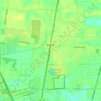
Name: Baker topographic map, elevation, terrain.
Average elevation: 79 ft
Minimum elevation: 49 ft
Maximum elevation: 102 ft
Other topographic maps
Click on a map to view its topography, its elevation and its terrain.
Nicholson Estates
United States > Louisiana > East Baton Rouge Parish > Baton Rouge
Average elevation: 36 ft
Campus Lake
United States > Louisiana > East Baton Rouge Parish > Baton Rouge
Average elevation: 36 ft
Delmont Place
United States > Louisiana > East Baton Rouge Parish > Baton Rouge
Average elevation: 66 ft
Goodwood Estates
United States > Louisiana > East Baton Rouge Parish > Baton Rouge
Average elevation: 56 ft
Sherwood Forest
United States > Louisiana > East Baton Rouge Parish > Baton Rouge
Average elevation: 52 ft
Magnolia Heights
United States > Louisiana > East Baton Rouge Parish > Baton Rouge
Average elevation: 36 ft
Carmen Terrace
United States > Louisiana > East Baton Rouge Parish > Baton Rouge
Average elevation: 52 ft
Bell Fontaine
United States > Louisiana > East Baton Rouge Parish > Baton Rouge
Average elevation: 52 ft
Marwede Place
United States > Louisiana > East Baton Rouge Parish > Baton Rouge
Average elevation: 56 ft