
Make a donation
Gear up for your next adventure:
As an Amazon Associate, this site earns from qualifying purchases at no extra cost to you.
Cómpeta topographic map
Click on the map to display elevation.
Make a donation
Gear up for your next adventure:
As an Amazon Associate, this site earns from qualifying purchases at no extra cost to you.
Cómpeta
The highest point visible from the town is the Maroma (2,065 m). The topography of the terminus is quite hilly, especially in the northwest, which borders the province of Granada. Other important elevations are Cerro Lucero (1,779 m), Cisne (1,600 m), Verde (1,554 m) and Tajo de las Grajas, which has a length of 200 metres.
Make a donation
Gear up for your next adventure:
As an Amazon Associate, this site earns from qualifying purchases at no extra cost to you.
About this map
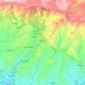
Name: Cómpeta topographic map, elevation, terrain.
Location: Cómpeta, La Axarquía, Malaga, Andalusia, 29754, Spain (36.78514 -3.99471 36.87372 -3.81520)
Average elevation: 2,277 ft
Minimum elevation: 89 ft
Maximum elevation: 6,496 ft
Make a donation
Gear up for your next adventure:
As an Amazon Associate, this site earns from qualifying purchases at no extra cost to you.
Other topographic maps
Click on a map to view its topography, its elevation and its terrain.
Maroma
Spain > Andalusia > La Axarquía > Canillas de Aceituno
La Maroma, also known as Tejeda, at an altitude of 2069 m, is the highest peak of the Sierra de Tejeda, Penibaetic System, Spain. The summit is located in the region of Axarquía on the border between the provinces of Granada and Málaga.
Average elevation: 5,597 ft
Make a donation
Gear up for your next adventure:
As an Amazon Associate, this site earns from qualifying purchases at no extra cost to you.
Make a donation
Gear up for your next adventure:
As an Amazon Associate, this site earns from qualifying purchases at no extra cost to you.
Make a donation
Gear up for your next adventure:
As an Amazon Associate, this site earns from qualifying purchases at no extra cost to you.