
Make a donation
Gear up for your next adventure:
As an Amazon Associate, this site earns from qualifying purchases at no extra cost to you.
Gravel Spring topographic map
Click on the map to display elevation.
Make a donation
Gear up for your next adventure:
As an Amazon Associate, this site earns from qualifying purchases at no extra cost to you.
About this map
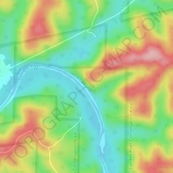
Name: Gravel Spring topographic map, elevation, terrain.
Average elevation: 689 ft
Minimum elevation: 482 ft
Maximum elevation: 974 ft
Shannon County trails, hiking, mountain biking, running and outdoor activities
Make a donation
Gear up for your next adventure:
As an Amazon Associate, this site earns from qualifying purchases at no extra cost to you.
Other topographic maps
Click on a map to view its topography, its elevation and its terrain.
Eminence
United States > Missouri > Shannon County
A post office called Eminence has been in operation since 1844. According to one account, Eminence was so named on account of its lofty elevation, however, this interpretation is disputed.
Average elevation: 725 ft
Eminence
United States > Missouri > Shannon County
A post office called Eminence has been in operation since 1844. According to one account, Eminence was so named on account of its lofty elevation, however, this interpretation is disputed.
Average elevation: 725 ft
Make a donation
Gear up for your next adventure:
As an Amazon Associate, this site earns from qualifying purchases at no extra cost to you.
Eminence
United States > Missouri > Shannon County
A post office called Eminence has been in operation since 1844. According to one account, Eminence was so named on account of its lofty elevation, however, this interpretation is disputed.
Average elevation: 725 ft