
Make a donation
Gear up for your next adventure:
As an Amazon Associate, this site earns from qualifying purchases at no extra cost to you.
Eminence topographic map
Click on the map to display elevation.
Make a donation
Gear up for your next adventure:
As an Amazon Associate, this site earns from qualifying purchases at no extra cost to you.
Eminence
A post office called Eminence has been in operation since 1844. According to one account, Eminence was so named on account of its lofty elevation, however, this interpretation is disputed.
Make a donation
Gear up for your next adventure:
As an Amazon Associate, this site earns from qualifying purchases at no extra cost to you.
About this map
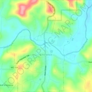
Name: Eminence topographic map, elevation, terrain.
Location: Eminence, Shannon County, Missouri, United States (37.13800 -91.37407 37.16895 -91.34667)
Average elevation: 725 ft
Minimum elevation: 594 ft
Maximum elevation: 1,001 ft
Shannon County trails, hiking, mountain biking, running and outdoor activities
Make a donation
Gear up for your next adventure:
As an Amazon Associate, this site earns from qualifying purchases at no extra cost to you.
Other topographic maps
Click on a map to view its topography, its elevation and its terrain.