
Make a donation
Gear up for your next adventure:
As an Amazon Associate, this site earns from qualifying purchases at no extra cost to you.
Mainz topographic map
Click on the map to display elevation.
Make a donation
Gear up for your next adventure:
As an Amazon Associate, this site earns from qualifying purchases at no extra cost to you.
Mainz
The destruction caused by the Bombing of Mainz in World War II led to the most intense phase of building in the history of the town. During the last war in Germany, more than 30 air raids destroyed about 80 per cent of the city's centre, including most of the historic buildings. The attack on the afternoon of 27 February 1945 remains the most destructive of all 33 bombings that Mainz has suffered in World War II in the collective memory of most of the population living then. The air raid caused most of the dead and made an already hard-hit city largely levelled. Nevertheless, the post-war reconstruction took place very slowly. While cities such as Frankfurt had been rebuilt fast by a central authority, only individual efforts were initially successful in rebuilding Mainz. The reason for this was that the French wanted Mainz to expand and become a model city. Mainz lay within the French-controlled sector of Germany and it was a French architect and town-planner, Marcel Lods, who produced a Le Corbusier-style plan of an ideal architecture. But the first interest of the inhabitants was the restoration of housing areas. Even after the failure of the model city plans it was the initiative of the French (founding of the Johannes Gutenberg University of Mainz, elevation of Mainz to the state capital of Rhineland-Palatinate, the early resumption of the Mainz carnival) driving the city in a positive development after the war. The City Plan of 1958 by Ernst May allowed a regulated reconstruction for the first time. In 1950, the seat of the government of Rhineland-Palatinate had been transferred to the new Mainz and in 1963 the seat of the new ZDF, notable architects were Adolf Bayer, Richard Jörg and Egon Hartmann. At the time of the two-thousand-years-anniversary in 1962 the city was largely reconstructed. During the 1950s and 1960s, the Oberstadt had been extended, Münchfeld and Lerchenberg added as suburbs, the Altstadttangente (intersection of the old town), new neighbourhoods as Westring and Südring contributed to the extension. By 1970 there remained only a few ruins. The new town hall of Mainz had been designed by Arne Jacobsen and finished by Dissing+Weitling. The town used Jacobsens activity for the Danish Novo company erecting a new office and warehouse building to contact him. The urban renewal of the old town changed the inner city. In the framework of the preparation of the cathedrals millennium, pedestrian zones were developed around the cathedral, in northern direction to the Neubrunnenplatz and in a southern direction across the Leichhof to the Augustinerstraße and Kirschgarten. The 1980s brought the renewal of the façades on the Markt and a new inner-city neighbourhood on the Kästrich. During the 1990s the Kisselberg and the "Fort Malakoff Center" at the site of the old police barracks were built.
Make a donation
Gear up for your next adventure:
As an Amazon Associate, this site earns from qualifying purchases at no extra cost to you.
About this map
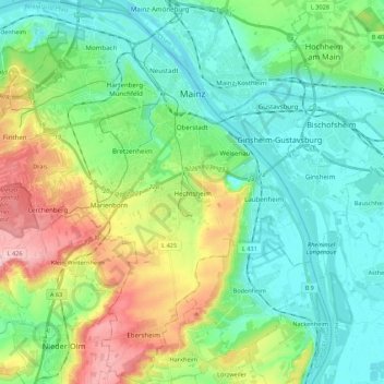
Name: Mainz topographic map, elevation, terrain.
Location: Mainz, Rhineland-Palatinate, Germany (49.89553 8.14309 50.03530 8.34314)
Average elevation: 433 ft
Minimum elevation: 259 ft
Maximum elevation: 856 ft
Make a donation
Gear up for your next adventure:
As an Amazon Associate, this site earns from qualifying purchases at no extra cost to you.
Other topographic maps
Click on a map to view its topography, its elevation and its terrain.
Monbijou
Germany > Rhineland-Palatinate > Südwestpfalz > Dietrichingen > Monbijou
Average elevation: 991 ft
Wingendorf
Germany > Rhineland-Palatinate > Landkreis Altenkirchen (Westerwald)
Average elevation: 935 ft
Rhine Gorge
Germany > Rhineland-Palatinate > Rhein-Hunsrück-Kreis > Sankt Goar > Biebernheim
Average elevation: 581 ft
Rhine Gorge
Germany > Rhineland-Palatinate > Rhein-Hunsrück-Kreis > Sankt Goar > Biebernheim
Average elevation: 581 ft
Make a donation
Gear up for your next adventure:
As an Amazon Associate, this site earns from qualifying purchases at no extra cost to you.
Waldfischbach
Germany > Rhineland-Palatinate > Südwestpfalz > Waldfischbach-Burgalben
Average elevation: 1,070 ft
Der Auborn
Germany > Rhineland-Palatinate > Landkreis Südliche Weinstraße > Schweighofen
Average elevation: 509 ft
Erbel
Germany > Rhineland-Palatinate > Landkreis Altenkirchen (Westerwald) > Fluterschen
Average elevation: 922 ft
Make a donation
Gear up for your next adventure:
As an Amazon Associate, this site earns from qualifying purchases at no extra cost to you.
Eltz Castle
Germany > Rhineland-Palatinate > Landkreis Mayen-Koblenz > Wierschem
Average elevation: 719 ft
Berwartstein
Germany > Rhineland-Palatinate > Südwestpfalz > Erlenbach bei Dahn
Average elevation: 912 ft
Eifel
Germany > Rhineland-Palatinate > Landkreis Ahrweiler > Adenau
The Eifel is in the Atlantic climate zone with its relatively high precipitation; winters that are moderately cold and long with periods of snow; and summers that are often humid and cool. The prevailing wind is west/southwest. A relatively dry and milder climate prevails in the wind and rain shadow of the…
Average elevation: 1,919 ft
Make a donation
Gear up for your next adventure:
As an Amazon Associate, this site earns from qualifying purchases at no extra cost to you.
Air Base
Germany > Rhineland-Palatinate > Landkreis Kaiserslautern > Ramstein-Miesenbach
Average elevation: 778 ft
Eifel
Germany > Rhineland-Palatinate > Landkreis Ahrweiler > Adenau
The Eifel is in the Atlantic climate zone with its relatively high precipitation; winters that are moderately cold and long with periods of snow; and summers that are often humid and cool. The prevailing wind is west/southwest. A relatively dry and milder climate prevails in the wind and rain shadow of the…
Average elevation: 1,919 ft
Make a donation
Gear up for your next adventure:
As an Amazon Associate, this site earns from qualifying purchases at no extra cost to you.
Make a donation
Gear up for your next adventure:
As an Amazon Associate, this site earns from qualifying purchases at no extra cost to you.
Katz Castle
Germany > Rhineland-Palatinate > Rhein-Lahn-Kreis > Sankt Goarshausen > Heide
Average elevation: 584 ft
Schönenberg
Germany > Rhineland-Palatinate > Landkreis Kusel > Schönenberg-Kübelberg
Average elevation: 873 ft
Make a donation
Gear up for your next adventure:
As an Amazon Associate, this site earns from qualifying purchases at no extra cost to you.
Heldberg
Germany > Rhineland-Palatinate > Landkreis Trier-Saarburg > Klüsserath
Average elevation: 705 ft
Hinterhausen
Germany > Rhineland-Palatinate > Landkreis Vulkaneifel > Gerolstein
Average elevation: 1,493 ft
Make a donation
Gear up for your next adventure:
As an Amazon Associate, this site earns from qualifying purchases at no extra cost to you.
Make a donation
Gear up for your next adventure:
As an Amazon Associate, this site earns from qualifying purchases at no extra cost to you.
Weiperath
Germany > Rhineland-Palatinate > Landkreis Bernkastel-Wittlich > Morbach
The municipality lies at an elevation of between 430 and 770 m above sea level in the low mountain range of the Hunsrück on the boundary with the Birkenfeld district, roughly 25 km southeast of Wittlich and 35 km east of Trier. Its population is 11,051. The nearest town is Bernkastel-Kues.
Average elevation: 1,440 ft
Make a donation
Gear up for your next adventure:
As an Amazon Associate, this site earns from qualifying purchases at no extra cost to you.
Wolf
Germany > Rhineland-Palatinate > Landkreis Bernkastel-Wittlich > Traben-Trarbach
Average elevation: 659 ft
Make a donation
Gear up for your next adventure:
As an Amazon Associate, this site earns from qualifying purchases at no extra cost to you.
Dünebusch
Germany > Rhineland-Palatinate > Landkreis Altenkirchen (Westerwald) > Bitzen
Average elevation: 676 ft
Eifel
Germany > Rhineland-Palatinate > Landkreis Ahrweiler > Adenau
The Eifel is in the Atlantic climate zone with its relatively high precipitation; winters that are moderately cold and long with periods of snow; and summers that are often humid and cool. The prevailing wind is west/southwest. A relatively dry and milder climate prevails in the wind and rain shadow of the…
Average elevation: 1,919 ft
Moselhöhe Ediger-Eller
Germany > Rhineland-Palatinate > Landkreis Cochem-Zell > Ediger-Eller
Average elevation: 935 ft
Make a donation
Gear up for your next adventure:
As an Amazon Associate, this site earns from qualifying purchases at no extra cost to you.
Hallenbad Idar-Oberstein
Germany > Rhineland-Palatinate > Landkreis Birkenfeld > Idar-Oberstein
Average elevation: 1,125 ft
Wittlich
Germany > Rhineland-Palatinate > Landkreis Bernkastel-Wittlich > Wittlich
Average elevation: 778 ft
Make a donation
Gear up for your next adventure:
As an Amazon Associate, this site earns from qualifying purchases at no extra cost to you.
Miesenheim
Germany > Rhineland-Palatinate > Landkreis Mayen-Koblenz > Andernach
Average elevation: 394 ft
Ferres
Germany > Rhineland-Palatinate > Landkreis Bernkastel-Wittlich > Piesport > Ferres
Average elevation: 856 ft
Ettringer Bellberg
Germany > Rhineland-Palatinate > Landkreis Mayen-Koblenz > Ettringen
Average elevation: 1,122 ft
Make a donation
Gear up for your next adventure:
As an Amazon Associate, this site earns from qualifying purchases at no extra cost to you.
Eulenbis
Germany > Rhineland-Palatinate > Landkreis Kaiserslautern > Eulenbis > Eulenbis
Average elevation: 994 ft
Make a donation
Gear up for your next adventure:
As an Amazon Associate, this site earns from qualifying purchases at no extra cost to you.
Haubendell
Germany > Rhineland-Palatinate > Eifelkreis Bitburg-Prüm > Karlshausen > Haubendell
Average elevation: 1,480 ft
Berghausen
Germany > Rhineland-Palatinate > Rhein-Lahn-Kreis > Berghausen > Berghausen
Average elevation: 1,102 ft
Burg Nanstein
Germany > Rhineland-Palatinate > Landkreis Kaiserslautern > Landstuhl
Average elevation: 994 ft
Make a donation
Gear up for your next adventure:
As an Amazon Associate, this site earns from qualifying purchases at no extra cost to you.
Pellenberg
Germany > Rhineland-Palatinate > Landkreis Trier-Saarburg > Merzkirchen
Average elevation: 1,138 ft
Brunnel
Germany > Rhineland-Palatinate > Landkreis Südliche Weinstraße > Steinfeld (Pfalz)
Average elevation: 459 ft