
Make a donation
Gear up for your next adventure:
As an Amazon Associate, this site earns from qualifying purchases at no extra cost to you.
Darchula District (Nepal) topographic map
Click on the map to display elevation.
Make a donation
Gear up for your next adventure:
As an Amazon Associate, this site earns from qualifying purchases at no extra cost to you.
Darchula District (Nepal)
The Himalayan region between two rivers Kali River to Seti River calls Gurans Himal. Darchula district falls in the Gurans Himal zone. Api Himal (7,132 metres (23,399 ft)) and Jethi Bahurani (6,850 metres (22,470 ft)) are main mountain peaks of the area. There is a protected area named Api Nampa Conservation Area which ranges in elevation from 532 metres (1,745 ft) to 7,132 metres (23,399 ft). Mahakali, Chalune, Tinkar, Nampa and Kalagad are the rivers in the area.
Make a donation
Gear up for your next adventure:
As an Amazon Associate, this site earns from qualifying purchases at no extra cost to you.
About this map
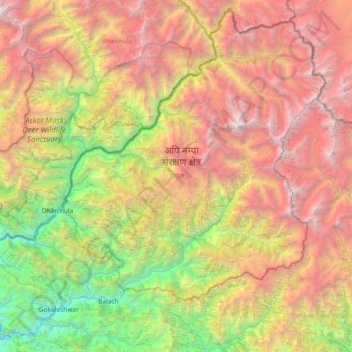
Name: Darchula District (Nepal) topographic map, elevation, terrain.
Location: Darchula District (Nepal), Sudurpashchim Province, Nepal (29.60492 80.36410 30.21972 81.10904)
Average elevation: 11,112 ft
Minimum elevation: 1,850 ft
Maximum elevation: 23,153 ft
Make a donation
Gear up for your next adventure:
As an Amazon Associate, this site earns from qualifying purchases at no extra cost to you.
Other topographic maps
Click on a map to view its topography, its elevation and its terrain.
Make a donation
Gear up for your next adventure:
As an Amazon Associate, this site earns from qualifying purchases at no extra cost to you.
Make a donation
Gear up for your next adventure:
As an Amazon Associate, this site earns from qualifying purchases at no extra cost to you.
Make a donation
Gear up for your next adventure:
As an Amazon Associate, this site earns from qualifying purchases at no extra cost to you.
Jogbuda Nadi
Nepal > Sudurpashchim Province > Kanchanpur District > Jamunaghadi
Average elevation: 669 ft
Make a donation
Gear up for your next adventure:
As an Amazon Associate, this site earns from qualifying purchases at no extra cost to you.
Make a donation
Gear up for your next adventure:
As an Amazon Associate, this site earns from qualifying purchases at no extra cost to you.
Make a donation
Gear up for your next adventure:
As an Amazon Associate, this site earns from qualifying purchases at no extra cost to you.
Make a donation
Gear up for your next adventure:
As an Amazon Associate, this site earns from qualifying purchases at no extra cost to you.