Geolocate

Mogollon Rim topographic map

Click on the map to display elevation.

About this map

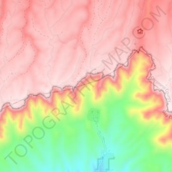
Name: Mogollon Rim topographic map, elevation, terrain.

Location: Mogollon Rim, Rim Road, Coconino County, Arizona, USA (34.42672 -111.31086 34.45339 -111.23973)

Average elevation: 6,916 ft

Minimum elevation: 5,666 ft

Maximum elevation: 7,671 ft

Other topographic maps

Click on a map to view its topography, its elevation and its terrain.

Tucson Mountain Park

USA > Arizona > Tucson Estates

Average elevation: 2,667 ft

Yuma

USA > Arizona > Yuma

Average elevation: 226 ft

Prescott National Forest

USA > Arizona

Average elevation: 5,249 ft

Coconino National Forest

USA > Arizona > Pilgrim Playground

Average elevation: 5,938 ft

Coronado National Forest

USA > Arizona > Oro Blanco

Average elevation: 3,136 ft

Kaibab National Forest

USA > Arizona > Williams

Average elevation: 5,751 ft

Gear up for your next adventure:

🌧️Backpack Rain Cover - Keep gear dry in wet weather
👟Men's Trail Runners - Lightweight footwear for fast-paced exploration and light hiking
🌡️Handheld Weather Meters - Measure wind, temp, and pressure for safe mountain travel
🧭Hiking Compass - Precision compass for reliable navigation in the wilderness
🔦Compact Flashlight - Reliable flashlight for emergencies

As an Amazon Associate, this site earns from qualifying purchases at no extra cost to you.