
Make a donation
Gear up for your next adventure:
As an Amazon Associate, this site earns from qualifying purchases at no extra cost to you.
New Westminster topographic map
Click on the map to display elevation.
Make a donation
Gear up for your next adventure:
As an Amazon Associate, this site earns from qualifying purchases at no extra cost to you.
About this map
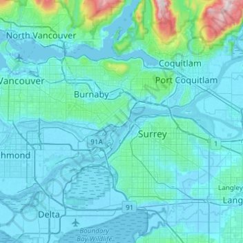
Name: New Westminster topographic map, elevation, terrain.
Average elevation: 285 ft
Minimum elevation: -13 ft
Maximum elevation: 3,911 ft
Make a donation
Gear up for your next adventure:
As an Amazon Associate, this site earns from qualifying purchases at no extra cost to you.
Other topographic maps
Click on a map to view its topography, its elevation and its terrain.
Tsawwassen First Nation
Canada > British Columbia > Metro Vancouver Regional District
Average elevation: 16 ft
Coquitlam Watershed
Canada > British Columbia > Metro Vancouver Regional District > Electoral Area A
Average elevation: 2,208 ft
Hillcrest Park
Canada > British Columbia > Metro Vancouver Regional District > Vancouver
Average elevation: 249 ft
Make a donation
Gear up for your next adventure:
As an Amazon Associate, this site earns from qualifying purchases at no extra cost to you.
Kitsilano
Canada > British Columbia > Metro Vancouver Regional District > Vancouver
Average elevation: 79 ft
West End
Canada > British Columbia > Metro Vancouver Regional District > Vancouver
Average elevation: 49 ft
Victoria-Fraserview
Canada > British Columbia > Metro Vancouver Regional District > Vancouver
Average elevation: 236 ft
Fairview
Canada > British Columbia > Metro Vancouver Regional District > Vancouver
Average elevation: 105 ft
Make a donation
Gear up for your next adventure:
As an Amazon Associate, this site earns from qualifying purchases at no extra cost to you.
Mundy Park
Canada > British Columbia > Metro Vancouver Regional District > Coquitlam
Average elevation: 456 ft
Metro Vancouver Regional Parks
Canada > British Columbia > Metro Vancouver Regional District > Electoral Area A
Average elevation: 627 ft