
Make a donation
Gear up for your next adventure:
As an Amazon Associate, this site earns from qualifying purchases at no extra cost to you.
Py topographic map
Click on the map to display elevation.
Make a donation
Gear up for your next adventure:
As an Amazon Associate, this site earns from qualifying purchases at no extra cost to you.
About this map
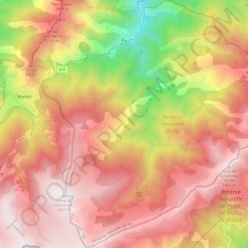
Name: Py topographic map, elevation, terrain.
Average elevation: 5,994 ft
Minimum elevation: 2,792 ft
Maximum elevation: 8,048 ft
Make a donation
Gear up for your next adventure:
As an Amazon Associate, this site earns from qualifying purchases at no extra cost to you.
Other topographic maps
Click on a map to view its topography, its elevation and its terrain.
Font-Romeu
Francia > Occitania > Pirineos Orientales > Font-Romeu-Odeillo-Via
Average elevation: 5,610 ft
Make a donation
Gear up for your next adventure:
As an Amazon Associate, this site earns from qualifying purchases at no extra cost to you.
Angoustrine
Francia > Occitania > Pirineos Orientales > Angoustrine-Villeneuve-des-Escaldes
Average elevation: 4,724 ft
Pic Carlit
Francia > Occitania > Pirineos Orientales > Angoustrine-Villeneuve-des-Escaldes
Average elevation: 8,461 ft
Puig de la Tossa
Francia > Occitania > Pirineos Orientales > Ayguatébia-Talau
Average elevation: 6,063 ft
Puig d'en Valls
Francia > Occitania > Pirineos Orientales > Prunet-et-Belpuig
Average elevation: 2,011 ft
Make a donation
Gear up for your next adventure:
As an Amazon Associate, this site earns from qualifying purchases at no extra cost to you.
Make a donation
Gear up for your next adventure:
As an Amazon Associate, this site earns from qualifying purchases at no extra cost to you.
La Tuilerie Neuve
Francia > Occitania > Pirineos Orientales > Maureillas-las-Illas
Average elevation: 499 ft
Make a donation
Gear up for your next adventure:
As an Amazon Associate, this site earns from qualifying purchases at no extra cost to you.
Pic de la Falguerosa
Francia > Occitania > Pirineos Orientales > Vernet-les-Bains > Casteil
Average elevation: 2,825 ft