
Make a donation
Gear up for your next adventure:
As an Amazon Associate, this site earns from qualifying purchases at no extra cost to you.
Bhopal topographic map
Click on the map to display elevation.
Make a donation
Gear up for your next adventure:
As an Amazon Associate, this site earns from qualifying purchases at no extra cost to you.
Bhopal
Bhopal has an average elevation of 500 metres (1,401 ft) and is located in the central part of India, just north of the upper limit of the Vindhya mountain ranges. Located on the Malwa plateau, it is higher than the north Indian plains and the land rises towards the Vindhya Range to the south. The city has uneven elevation and has small hills within its boundaries. The prominent hills in Bhopal are the Idgah, Arera and Shyamala hills in the northern region, together with the Katara hills in the southern region. There are 17 lakes and 5 reservoirs biggest of them are upper lake (Bada Talab) and lower lake. The Upper Lake was built in the 11th century and has a surface area of 36 km2 and catchment area of 361 km2 while the Lower Lake has a surface area of 1.29 km2 and catchment area of 9.6 km2. Recently, Bhopal Municipal Corporation came with a resolution to involve local citizens in cleaning, conserving and maintaining the lakes. Bhopal city is divided into two parts where one part which is near the VIP road and lake is Old Bhopal (north) and the other, New Bhopal (south), where malls are mainly situated. List of pin codes from Bhopal is 462001 to 462050 which comes under Bhopal postal division (Bhopal Region).
Make a donation
Gear up for your next adventure:
As an Amazon Associate, this site earns from qualifying purchases at no extra cost to you.
About this map
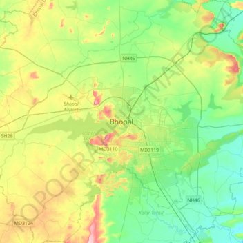
Name: Bhopal topographic map, elevation, terrain.
Location: Bhopal, Huzur Tahsil, Bhopal, Madhya Pradesh, 462001, India (23.09849 77.24199 23.41849 77.56199)
Average elevation: 1,634 ft
Minimum elevation: 1,427 ft
Maximum elevation: 2,070 ft
Make a donation
Gear up for your next adventure:
As an Amazon Associate, this site earns from qualifying purchases at no extra cost to you.
Other topographic maps
Click on a map to view its topography, its elevation and its terrain.
Make a donation
Gear up for your next adventure:
As an Amazon Associate, this site earns from qualifying purchases at no extra cost to you.
Make a donation
Gear up for your next adventure:
As an Amazon Associate, this site earns from qualifying purchases at no extra cost to you.
Make a donation
Gear up for your next adventure:
As an Amazon Associate, this site earns from qualifying purchases at no extra cost to you.