
Mount Hector topographic map
Click on the map to display elevation.
About this map
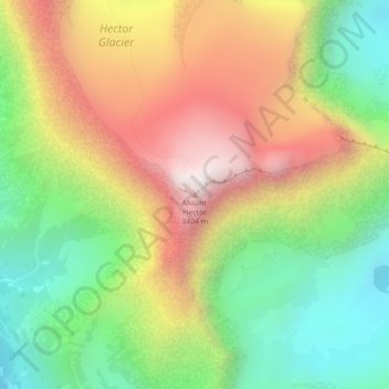
Name: Mount Hector topographic map, elevation, terrain.
Location: Mount Hector, Improvement District No. 9, Alberta, Canada (51.57471 -116.25951 51.57481 -116.25941)
Average elevation: 8,891 ft
Minimum elevation: 7,326 ft
Maximum elevation: 10,791 ft
Other topographic maps
Click on a map to view its topography, its elevation and its terrain.
Kootenay National Park
Canada > Alberta > Improvement District No. 9
Kootenay National Park is a national park of Canada located in southeastern British Columbia. The park consists of 1,406 km2 (543 sq mi) of the Canadian Rockies, including parts of the Kootenay and Park mountain ranges, the Kootenay River and the entirety of the Vermilion River. While the Vermilion River is…
Average elevation: 6,014 ft