Geolocate

Koli topographic map

Click on the map to display elevation.

About this map

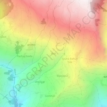
Name: Koli topographic map, elevation, terrain.

Location: Koli, Raskot, Kalikot, Karnali Province, Nepal (29.23424 81.61491 29.27424 81.65491)

Average elevation: 6,204 ft

Minimum elevation: 3,488 ft

Maximum elevation: 8,901 ft

Other topographic maps

Click on a map to view its topography, its elevation and its terrain.

Naraharinath

Nepal > Karnali Province > Kalikot

Average elevation: 7,382 ft

Gear up for your next adventure:

🚪Portable Camp Chair - Foldable chair for comfort at camp
🪶Trail Camera - Capture wildlife on your hikes
🗺️Topographic Maps - Detailed topo maps for hiking, exploring and outdoor navigation
🌄Hiking Binoculars - Compact binoculars for scenic views and trail spotting
🪶Thermal Camp Blanket - Extra warmth for cold nights

As an Amazon Associate, this site earns from qualifying purchases at no extra cost to you.