Geolocate

Lexington topographic map

Click on the map to display elevation.

About this map

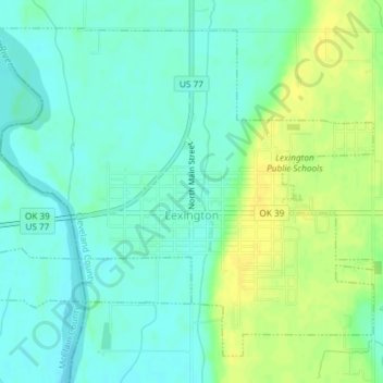
Name: Lexington topographic map, elevation, terrain.

Location: Lexington, Cleveland County, Oklahoma, United States (35.00367 -97.35495 35.02954 -97.31805)

Average elevation: 1,053 ft

Minimum elevation: 1,024 ft

Maximum elevation: 1,096 ft

Cleveland County trails, hiking, mountain biking, running and outdoor activities

Other topographic maps

Click on a map to view its topography, its elevation and its terrain.

Norman

United States > Oklahoma > Cleveland County > Norman

Average elevation: 1,168 ft

Moore

United States > Oklahoma > Cleveland County > Moore > Moore

Average elevation: 1,237 ft

Gear up for your next adventure:

🏫Relief Map Kits - Hands-on tools for teaching landforms and elevation
🦟Ultrasonic Repellers - Create a bug-free zone at your camp or rest stop
🌎3D Topographic Globes - Raised relief globes for a tactile understanding of geography
🏕️Tent Footprint - Protect your tent base from wear
🩳Quick‑Dry Hiking Shorts - Comfortable and quick‑dry shorts for summer hiking

As an Amazon Associate, this site earns from qualifying purchases at no extra cost to you.