Geolocate

Juneau topographic map

Click on the map to display elevation.

About this map

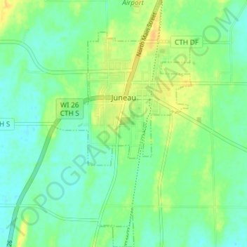
Name: Juneau topographic map, elevation, terrain.

Location: Juneau, Dodge County, Wisconsin, United States (43.37872 -88.72225 43.42281 -88.68852)

Average elevation: 896 ft

Minimum elevation: 860 ft

Maximum elevation: 948 ft

Dodge County trails, hiking, mountain biking, running and outdoor activities

Other topographic maps

Click on a map to view its topography, its elevation and its terrain.

Ashippun

United States > Wisconsin > Dodge County

Average elevation: 892 ft

Burnett

United States > Wisconsin > Dodge County

Average elevation: 892 ft

Rubicon

United States > Wisconsin > Dodge County

Average elevation: 1,040 ft

Lebanon

United States > Wisconsin > Dodge County

Average elevation: 912 ft

Gear up for your next adventure:

GPS Sports Watch - GPS watch for running, hiking and training
🛏️Cold Weather Sleeping Bag - Warm sleeping bag for cold conditions
🧯Emergency Survival Kit - All‑in‑one survival essentials for the backcountry
🥾Men's Hiking Boots - Durable, waterproof footwear for rugged terrain and steep inclines
🧣Hiking Neck Gaiter - Multi‑use neck protection for outdoor weather

As an Amazon Associate, this site earns from qualifying purchases at no extra cost to you.