
Make a donation
Gear up for your next adventure:
As an Amazon Associate, this site earns from qualifying purchases at no extra cost to you.
Mathis topographic map
Click on the map to display elevation.
Make a donation
Gear up for your next adventure:
As an Amazon Associate, this site earns from qualifying purchases at no extra cost to you.
About this map
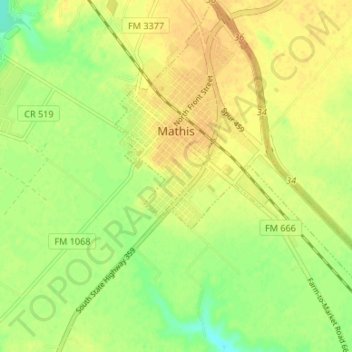
Name: Mathis topographic map, elevation, terrain.
Location: Mathis, San Patricio County, Texas, United States (28.05741 -97.83906 28.11606 -97.77807)
Average elevation: 141 ft
Minimum elevation: 79 ft
Maximum elevation: 180 ft
San Patricio County trails, hiking, mountain biking, running and outdoor activities
Make a donation
Gear up for your next adventure:
As an Amazon Associate, this site earns from qualifying purchases at no extra cost to you.
Other topographic maps
Click on a map to view its topography, its elevation and its terrain.
Garza-4th-6th Streets Colonia
United States > Texas > San Patricio County > Ingleside
Average elevation: 23 ft
Ingleside
United States > Texas > San Patricio County > Ingleside > Ingleside
Average elevation: 20 ft
Kenney Lane West Colonia
United States > Texas > San Patricio County > Ingleside > Kenney Lane West Colonia
Average elevation: 23 ft
Make a donation
Gear up for your next adventure:
As an Amazon Associate, this site earns from qualifying purchases at no extra cost to you.