Geolocate

Boston topographic map

Click on the map to display elevation.

About this map

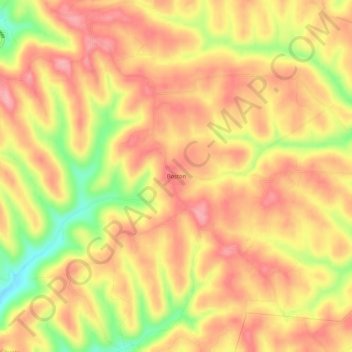
Name: Boston topographic map, elevation, terrain.

Location: Boston, Belmont County, Ohio, United States (39.86813 -81.21844 39.90813 -81.17844)

Average elevation: 1,201 ft

Minimum elevation: 945 ft

Maximum elevation: 1,345 ft

Belmont County trails, hiking, mountain biking, running and outdoor activities

Other topographic maps

Click on a map to view its topography, its elevation and its terrain.

Neffs

United States > Ohio > Belmont County > Neffs

Average elevation: 984 ft

Morristown

United States > Ohio > Belmont County

Average elevation: 1,227 ft

Flushing

United States > Ohio > Belmont County

Average elevation: 1,198 ft

Holloway

United States > Ohio > Belmont County

Average elevation: 1,027 ft

Brookside

United States > Ohio > Belmont County

Average elevation: 922 ft

Bridgeport

United States > Ohio > Belmont County

Average elevation: 801 ft

Bethesda

United States > Ohio > Belmont County

Average elevation: 1,234 ft

Belmont

United States > Ohio > Belmont County

Average elevation: 1,184 ft

Martins Ferry

United States > Ohio > Belmont County

Average elevation: 945 ft

Powhatan Point

United States > Ohio > Belmont County

Average elevation: 791 ft

Shadyside

United States > Ohio > Belmont County

Average elevation: 804 ft

Yorkville

United States > Ohio > Belmont County

Average elevation: 840 ft

Piedmont Lake

United States > Ohio > Belmont County

Average elevation: 1,053 ft

Gear up for your next adventure:

👟Trail Running Shoes - Lightweight shoes for trail runners
⛑️Personal Locator Beacon - Safety beacon for emergencies
🔥Camping Stove - Portable stove for camping and backcountry cooking
🥾Hiking Shoes - Durable and comfortable shoes for trail hiking
🛠️Outdoor Gear Repair Kit - Essential tools to fix gear on the trail

As an Amazon Associate, this site earns from qualifying purchases at no extra cost to you.