
Make a donation
Gear up for your next adventure:
As an Amazon Associate, this site earns from qualifying purchases at no extra cost to you.
American Falls topographic map
Click on the map to display elevation.
Make a donation
Gear up for your next adventure:
As an Amazon Associate, this site earns from qualifying purchases at no extra cost to you.
American Falls
American Falls is located at 42°46′52″N 112°51′20″W / 42.78111°N 112.85556°W / 42.78111; -112.85556 (42.781121, -112.855694), at an elevation of 4,406 feet (1,343 m).
Make a donation
Gear up for your next adventure:
As an Amazon Associate, this site earns from qualifying purchases at no extra cost to you.
About this map
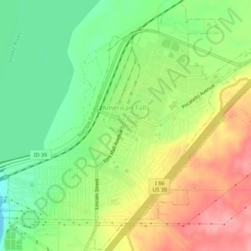
Name: American Falls topographic map, elevation, terrain.
Location: American Falls, Power County, Idaho, United States (42.76946 -112.87434 42.79841 -112.83439)
Average elevation: 4,416 ft
Minimum elevation: 4,252 ft
Maximum elevation: 4,613 ft
Power County trails, hiking, mountain biking, running and outdoor activities
Make a donation
Gear up for your next adventure:
As an Amazon Associate, this site earns from qualifying purchases at no extra cost to you.