Geolocate

Elgin topographic map

Click on the map to display elevation.

About this map

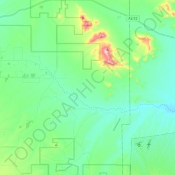
Name: Elgin topographic map, elevation, terrain.

Location: Elgin, Santa Cruz County, Arizona, United States (31.57759 -110.62089 31.72378 -110.45172)

Average elevation: 4,869 ft

Minimum elevation: 4,429 ft

Maximum elevation: 6,447 ft

Santa Cruz County trails, hiking, mountain biking, running and outdoor activities

Other topographic maps

Click on a map to view its topography, its elevation and its terrain.

Patagonia Lake

United States > Arizona > Santa Cruz County

Average elevation: 3,898 ft

Alto

United States > Arizona > Santa Cruz County

Average elevation: 4,918 ft

Thumb Butte

United States > Arizona > Santa Cruz County

Average elevation: 4,544 ft

Canelo

United States > Arizona > Santa Cruz County > Canelo

Average elevation: 5,079 ft

Gear up for your next adventure:

🗃️Trail First Aid Kit - Essential kit for outdoor injuries and emergencies
🚁Photography Drones - Capture stunning aerial views of landforms and topography
🧣Merino Neck Gaiters - Multi-functional headwear for wind and sun protection
🥤Water Filter Bottle - All‑in‑one filter bottle for safe hydration
🪶Camp Gear Gift Set - Perfect gift bundle for outdoor fans

As an Amazon Associate, this site earns from qualifying purchases at no extra cost to you.