
Town of Lowville topographic map
Interactive map
Click on the map to display elevation.
About this map
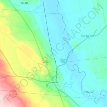
Name: Town of Lowville topographic map, elevation, terrain.
Average elevation: 948 ft
Minimum elevation: 712 ft
Maximum elevation: 1,762 ft
Lowville /ˈlaʊvɪl/ is a town in Lewis County, New York, United States. The population was 4,888 at the 2020 census, down from 4,982 in 2010. The town is near the center of the county and is southeast of the city of Watertown. The town of Lowville contains a village also named Lowville, which is the county seat. The town is named after Nicholas Low, an early landowner. Low was of Dutch descent, and had emigrated with his wife and three small children from a rural village outside Amsterdam in 1778. Despite popular folk etymology, the name Lowville has nothing to do with its low elevation or the lowing cattle of the many nearby dairy farms.
Other topographic maps
Click on a map to view its topography, its elevation and its terrain.
Harrisville
United States > New York > Lewis County
Harrisville, Town of Diana, Lewis County, New York, United States
Average elevation: 820 ft
Brantingham Lake
United States > New York > Lewis County > Town of Greig
Brantingham Lake, Town of Greig, Lewis County, New York, 13312, United States
Average elevation: 1,260 ft
Village of Lyons Falls
United States > New York > Lewis County
Village of Lyons Falls, Town of West Turin, Lewis County, New York, United States
Average elevation: 879 ft
Town of West Turin
United States > New York > Lewis County
Town of West Turin, Lewis County, New York, 13325, United States
Average elevation: 1,644 ft
Town of New Bremen
United States > New York > Lewis County
Town of New Bremen, Lewis County, New York, United States
Average elevation: 925 ft
Beaver River
United States > New York > Lewis County > Town of Croghan > Village of Croghan
Beaver River, Village of Croghan, Town of Croghan, Lewis County, New York, 13305, United States
Average elevation: 840 ft
Village of Castorland
United States > New York > Lewis County > Town of Denmark
Village of Castorland, Town of Denmark, Lewis County, New York, United States
Average elevation: 764 ft
Town of Leyden
United States > New York > Lewis County
Town of Leyden, Lewis County, New York, United States
Average elevation: 1,302 ft
Town of Lewis
United States > New York > Lewis County
Town of Lewis, Lewis County, New York, 13489, United States
Average elevation: 1,503 ft
Montague
United States > New York > Lewis County
Montague, Lewis County, New York, United States
Average elevation: 1,542 ft
Town of Pinckney
United States > New York > Lewis County
Town of Pinckney, Lewis County, New York, 13626, United States
Average elevation: 1,447 ft
Beartown State Forest
United States > New York > Lewis County > Town of Croghan
Beartown State Forest, Town of Croghan, Town of Wilna, Lewis County, New York, United States
Average elevation: 879 ft
Brantingham
United States > New York > Lewis County > Brantingham
Brantingham, Greig, Lewis County, New York, 13345, United States
Average elevation: 1,250 ft
Belfort
United States > New York > Lewis County > Belfort
Belfort, Lewis County, New York, 13327, United States
Average elevation: 1,024 ft
Boonville Forest Preserve Detached Parcel
United States > New York > Lewis County
Boonville Forest Preserve Detached Parcel, Town of Boonville, Lewis County, New York, United States
Average elevation: 1,165 ft
Pleasant Lake
United States > New York > Lewis County > Brantingham
Pleasant Lake, Brantingham, Lewis County, New York, United States
Average elevation: 1,260 ft
Village of Lowville
United States > New York > Lewis County
Village of Lowville, Town of Lowville, Lewis County, New York, United States
Average elevation: 935 ft