Geolocate

Swan Falls topographic map

Click on the map to display elevation.

About this map

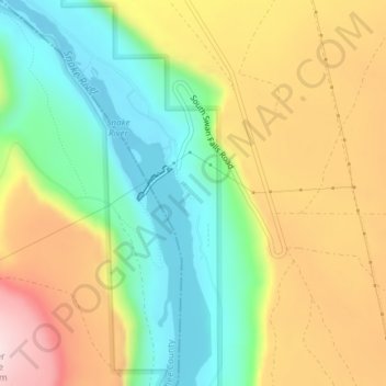
Name: Swan Falls topographic map, elevation, terrain.

Location: Swan Falls, Ada County, Idaho, United States (43.23227 -116.38574 43.25227 -116.36574)

Average elevation: 2,762 ft

Minimum elevation: 2,274 ft

Maximum elevation: 3,386 ft

Ada County trails, hiking, mountain biking, running and outdoor activities

Other topographic maps

Click on a map to view its topography, its elevation and its terrain.

Hidden Springs

United States > Idaho > Ada County

Average elevation: 2,992 ft

Boise Cascade Lake

United States > Idaho > Ada County > Boise

Average elevation: 2,671 ft

Eagle Island State Park

United States > Idaho > Ada County > Eagle

Average elevation: 2,536 ft

Gear up for your next adventure:

🪶Fire Starter Kit - Reliable fire starter for survival and camping
🔭Telescopic Hiking Pole - Adjustable pole for hiking stability
Camping Coffee Makers - Enjoy premium coffee at the summit or campsite
📦Dry Bags Set - Waterproof storage for electronics and clothes
🗻Climbing Gear Basics - Essential gear for beginner climbers

As an Amazon Associate, this site earns from qualifying purchases at no extra cost to you.