Geolocate

Cedartown topographic map

Click on the map to display elevation.

About this map

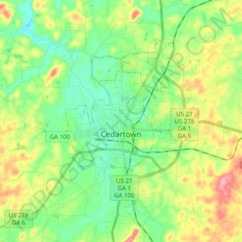
Name: Cedartown topographic map, elevation, terrain.

Location: Cedartown, Polk County, Georgia, 30125, United States (33.96199 -85.29953 34.07512 -85.16750)

Average elevation: 853 ft

Minimum elevation: 719 ft

Maximum elevation: 1,102 ft

Polk County trails, hiking, mountain biking, running and outdoor activities

Other topographic maps

Click on a map to view its topography, its elevation and its terrain.

Caseyville

United States > Georgia > Polk County

Average elevation: 997 ft

Vance Lake

United States > Georgia > Polk County > Cedartown

Average elevation: 801 ft

Gear up for your next adventure:

❄️Traction Cleats - Prevent slips on icy trails during winter hikes
🧣Hiking Neck Gaiter - Multi‑use neck protection for outdoor weather
🪶Thermal Camp Blanket - Extra warmth for cold nights
🥤Water Filter Bottle - All‑in‑one filter bottle for safe hydration
🗺️NatGeo Topo Maps - High-quality waterproof printed topographic maps of US Parks

As an Amazon Associate, this site earns from qualifying purchases at no extra cost to you.