Geolocate

Svetly topographic map

Click on the map to display elevation.

About this map
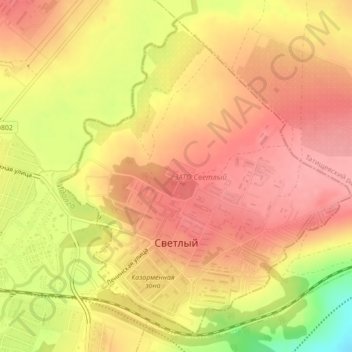
Name: Svetly topographic map, elevation, terrain.

Location: Svetly, Saratov Oblast, Volga Federal District, 412163, Russia (51.66674 45.60844 51.69079 45.64453)

Average elevation: 663 ft

Minimum elevation: 436 ft

Maximum elevation: 771 ft

Other topographic maps

Click on a map to view its topography, its elevation and its terrain.

Baranovka

Russia > Saratov Oblast > Volsky District

Average elevation: 151 ft

Алай

Russia > Saratov Oblast > Baltaysky District

Average elevation: 377 ft

Грачи

Russia > Saratov Oblast > Balakovsky District

Average elevation: 292 ft

Михайловка

Russia > Saratov Oblast > Saratov

Average elevation: 686 ft

Kurilovka

Russia > Saratov Oblast > Novouzensky District

Average elevation: 118 ft

Gear up for your next adventure:

🧼Biodegradable Camping Soap - Eco‑friendly soap for outdoor hygiene
🛏️Cold Weather Sleeping Bag - Warm sleeping bag for cold conditions
🧭Pro Hiking Compasses - High-accuracy liquid-filled compasses for topographic orientation
🪶Paracord Bracelet - Survival bracelet with built‑in tools
🎒Trail Energy Bars - High‑calorie bars for hiking energy

As an Amazon Associate, this site earns from qualifying purchases at no extra cost to you.