Geolocate

Syena topographic map

Click on the map to display elevation.

About this map

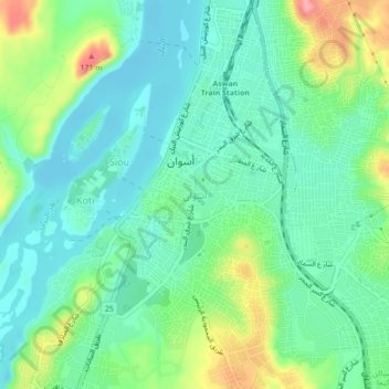
Name: Syena topographic map, elevation, terrain.

Location: Syena, Aswan, 81511, Egypt (24.06750 32.87889 24.10750 32.91889)

Average elevation: 374 ft

Minimum elevation: 262 ft

Maximum elevation: 640 ft

Other topographic maps

Click on a map to view its topography, its elevation and its terrain.

Al Bosiliah Bahary City

Egypt > Aswan

Average elevation: 318 ft

Nasr Al Nouba City

Egypt > Aswan

Average elevation: 374 ft

Abu Simbel City

Egypt > Aswan

Average elevation: 604 ft

Nagaa Al Mahata

Egypt > Aswan

Average elevation: 400 ft

Badr Al Din

Egypt > Aswan

Average elevation: 410 ft

Wadi Sebua

Egypt > Aswan

Average elevation: 633 ft

Gear up for your next adventure:

🔊Portable Camp Speaker - Music and alerts at camp
🌧️Backpack Rain Cover - Keep gear dry in wet weather
🏕️Tent Footprint - Protect your tent base from wear
🚗GPS Dash Cams - Record your scenic drives through mountain passes and canyons
🔭Stargazing Telescopes - Perfect for camping in low-light pollution areas shown on maps

As an Amazon Associate, this site earns from qualifying purchases at no extra cost to you.