
Hampstead topographic map
Interactive map
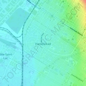
Click on the map to display elevation.
About this map
Name: Hampstead topographic map, elevation, terrain.
Average elevation: 187 ft
Minimum elevation: 154 ft
Maximum elevation: 312 ft
The Town of Hampstead was founded in 1914. It was designed to be an exclusive garden city. There are no retail shops within municipal boundaries. Houses were assigned relatively large lots to allow space for trees and shrubbery. The town's roads were designed with curves in order to slow down traffic and to create an interesting and intimate landscape. Despite its rather flat topography—much of the territory was once a golf course—the town was named after another garden city, the London suburb of Hampstead Village. Like its namesake, Hampstead is the home of many affluent citizens, and competes with a few other suburbs for first place in the rankings of highest average household incomes in Canada.
Other topographic maps
Click on a map to view its topography, its elevation and its terrain.
Montreal
Canada > Quebec > Urban agglomeration of Montreal
Montreal, Urban agglomeration of Montreal, Montreal (administrative region), Quebec, Canada
Average elevation: 95 ft
Mount Royal
Canada > Quebec > Urban agglomeration of Montreal > Montreal
Mount Royal, Montreal, Urban agglomeration of Montreal, Montreal (administrative region), Quebec, H3A 2B7, Canada
Average elevation: 364 ft
Rivière des Prairies
Canada > Quebec > Urban agglomeration of Montreal > Montreal
Rivière des Prairies, Montreal, Urban agglomeration of Montreal, Montreal (administrative region), Quebec, Canada
Average elevation: 118 ft
Parc de la Rive-Boisée
Canada > Quebec > Urban agglomeration of Montreal > Montreal
Parc de la Rive-Boisée, Pierrefonds-Roxboro, Montreal, Urban agglomeration of Montreal, Montreal (administrative region), Quebec, Canada
Average elevation: 95 ft
Rivière des Prairies
Canada > Quebec > Urban agglomeration of Montreal > Montreal
Rivière des Prairies, Montreal, Urban agglomeration of Montreal, Montreal (administrative region), Quebec, Canada
Average elevation: 112 ft
Île Bizard
Canada > Quebec > Urban agglomeration of Montreal > Montreal
Île Bizard, Montreal, Urban agglomeration of Montreal, Montreal (administrative region), Quebec, Canada
Average elevation: 95 ft
Pierrefonds-Roxboro
Canada > Quebec > Urban agglomeration of Montreal > Montreal
Pierrefonds-Roxboro, Montreal, Urban agglomeration of Montreal, Montreal (06), Quebec, Canada
Average elevation: 98 ft
Île Dorval
Canada > Quebec > Urban agglomeration of Montreal > L'Île-Dorval
Île Dorval, L'Île-Dorval, Urban agglomeration of Montreal, Montreal (administrative region), Quebec, Canada
Average elevation: 72 ft
Mount Royal Park
Canada > Quebec > Urban agglomeration of Montreal > Montreal
Mount Royal Park, Ville-Marie, Montreal, Urban agglomeration of Montreal, Montreal (administrative region), Quebec, H3G 1A8, Canada
Average elevation: 361 ft
LaSalle
Canada > Quebec > Urban agglomeration of Montreal > Montreal
LaSalle, Montreal, Urban agglomeration of Montreal, Montreal (administrative region), Quebec, Canada
Average elevation: 98 ft
Lachine
Canada > Quebec > Urban agglomeration of Montreal > Montreal
Lachine, Montreal, Urban agglomeration of Montreal, Montreal (administrative region), Quebec, Canada
Average elevation: 112 ft
Parc Richelieu
Canada > Quebec > Urban agglomeration of Montreal > Montreal
Parc Richelieu, Pointe-aux-Trembles, Rivière-des-Prairies–Pointe-aux-Trembles, Montreal, Urban agglomeration of Montreal, Montreal (administrative region), Quebec, Canada
Average elevation: 49 ft
Sainte-Anne-de-Bellevue
Canada > Quebec > Urban agglomeration of Montreal
Sainte-Anne-de-Bellevue, Urban agglomeration of Montreal, Montreal (administrative region), Quebec, Canada
Average elevation: 98 ft
Pointe-Claire
Canada > Quebec > Urban agglomeration of Montreal
Pointe-Claire, Urban agglomeration of Montreal, Montreal (administrative region), Quebec, Canada
Average elevation: 98 ft
Beaconsfield
Canada > Quebec > Urban agglomeration of Montreal
Beaconsfield, Urban agglomeration of Montreal, Montreal (administrative region), Quebec, Canada
Average elevation: 92 ft
Nuns' Island
Canada > Quebec > Urban agglomeration of Montreal > Montreal
Nuns' Island, Verdun, Montreal, Urban agglomeration of Montreal, Montreal (06), Quebec, Canada
Average elevation: 43 ft
Banc de Châteauguay
Canada > Quebec > Urban agglomeration of Montreal > Dorval
Banc de Châteauguay, Dorval, Urban agglomeration of Montreal, Montreal (administrative region), Quebec, H9S 3J8, Canada
Average elevation: 66 ft
Westmount
Canada > Quebec > Urban agglomeration of Montreal
Westmount, Urban agglomeration of Montreal, Montreal (administrative region), Quebec, Canada
Average elevation: 256 ft
Montréal-Nord
Canada > Quebec > Urban agglomeration of Montreal > Montreal
Montréal-Nord, Montreal, Urban agglomeration of Montreal, Montreal (administrative region), Quebec, Canada
Average elevation: 102 ft
Outremont
Canada > Quebec > Urban agglomeration of Montreal > Montreal
Outremont, Montreal, Urban agglomeration of Montreal, Montreal (06), Quebec, Canada
Average elevation: 348 ft
Dorval
Canada > Quebec > Urban agglomeration of Montreal
Dorval, Urban agglomeration of Montreal, Montreal (06), Quebec, Canada
Average elevation: 95 ft
Dollard-des-Ormeaux
Canada > Quebec > Urban agglomeration of Montreal
Dollard-des-Ormeaux, Urban agglomeration of Montreal, Montreal (administrative region), Quebec, Canada
Average elevation: 112 ft
Côte Saint-Luc
Canada > Quebec > Urban agglomeration of Montreal
Côte Saint-Luc, Urban agglomeration of Montreal, Montreal (06), Quebec, Canada
Average elevation: 164 ft
Westmount Park
Canada > Quebec > Urban agglomeration of Montreal > Westmount
Westmount Park, Westmount, Urban agglomeration of Montreal, Montreal (06), Quebec, Canada
Average elevation: 217 ft
Parc-nature du Bois-de-Liesse
Canada > Quebec > Urban agglomeration of Montreal > Montreal
Parc-nature du Bois-de-Liesse, Boucle des Champs-Pitfield, Bois-Francs, Saint-Laurent, Montreal, Urban agglomeration of Montreal, Montreal (06), Quebec, H4S 0A3, Canada
Average elevation: 92 ft
Baie-D'Urfé
Canada > Quebec > Urban agglomeration of Montreal
Baie-D'Urfé, Urban agglomeration of Montreal, Montreal (administrative region), Quebec, Canada
Average elevation: 105 ft
Montréal-Est
Canada > Quebec > Urban agglomeration of Montreal
Montréal-Est, Urban agglomeration of Montreal, Montreal (administrative region), Quebec, Canada
Average elevation: 49 ft
Verdun
Canada > Quebec > Urban agglomeration of Montreal > Montreal
Verdun, Montreal, Urban agglomeration of Montreal, Montreal (administrative region), Quebec, Canada
Average elevation: 59 ft
Kirkland
Canada > Quebec > Urban agglomeration of Montreal
Kirkland, Urban agglomeration of Montreal, Montreal (administrative region), Quebec, Canada
Average elevation: 128 ft
Montreal West
Canada > Quebec > Urban agglomeration of Montreal
Montreal West, Urban agglomeration of Montreal, Montreal (administrative region), Quebec, Canada
Average elevation: 138 ft
Terra Cotta
Canada > Quebec > Urban agglomeration of Montreal > Pointe-Claire
Terra Cotta, Pointe-Claire, Urban agglomeration of Montreal, Montreal (06), Quebec, Canada
Average elevation: 118 ft
Senneville
Canada > Quebec > Urban agglomeration of Montreal
Senneville, Urban agglomeration of Montreal, Montreal (administrative region), Quebec, Canada
Average elevation: 89 ft