
Dorval topographic map
Click on the map to display elevation.
About this map
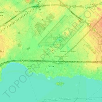
Name: Dorval topographic map, elevation, terrain.
Average elevation: 95 ft
Minimum elevation: 46 ft
Maximum elevation: 157 ft
Other topographic maps
Click on a map to view its topography, its elevation and its terrain.
Mount Royal
Canada > Quebec > Urban agglomeration of Montreal > Montreal
The hill is part of the Monteregian Hills situated between the Laurentians and the Appalachian Mountains. It gave its Latin name, Mons Regius, to the Monteregian chain. The hill consists of three peaks: Colline de la Croix (or Mont Royal proper) at 233 m (764 ft), Colline d'Outremont (or Mount Murray, in the…
Average elevation: 364 ft
Mount Royal Park
Canada > Quebec > Urban agglomeration of Montreal > Montreal
The mountain is part of the Monteregian Hills situated between the Laurentians and the Appalachian Mountains. It gave its Latin name, Mons Regius, to the Monteregian chain. The mountain consists of three peaks: Colline de la Croix (or Mont Royal proper) at 233 m (764 ft), Colline d'Outremont (or Mount Murray,…
Average elevation: 361 ft
Parc Léon-Provancher
Canada > Quebec > Urban agglomeration of Montreal > Montreal
Average elevation: 174 ft
Saint Helen's Island
Canada > Quebec > Urban agglomeration of Montreal > Montreal
Average elevation: 49 ft
Terra Cotta
Canada > Quebec > Urban agglomeration of Montreal > Pointe-Claire
Average elevation: 118 ft
Parc-nature du Bois-de-Liesse
Canada > Quebec > Urban agglomeration of Montreal > Montreal
Average elevation: 92 ft
Westmount Park
Canada > Quebec > Urban agglomeration of Montreal > Westmount
Average elevation: 217 ft
Banc de Châteauguay
Canada > Quebec > Urban agglomeration of Montreal > Dorval
Average elevation: 66 ft
Cap Saint-Jacques
Canada > Quebec > Urban agglomeration of Montreal > Montreal
Average elevation: 82 ft
Victoria Square
Canada > Quebec > Urban agglomeration of Montreal > Montreal
Average elevation: 102 ft
Mount Royal
Canada > Quebec > Urban agglomeration of Montreal > Montreal
The mountain is part of the Monteregian Hills situated between the Laurentians and the Appalachian Mountains. It gave its Latin name, Mons Regius, to the Monteregian chain. The mountain consists of three peaks: Colline de la Croix (or Mont Royal proper) at 233 m (764 ft), Colline d'Outremont (or Mount Murray,…
Average elevation: 364 ft
Victoria Square
Canada > Quebec > Urban agglomeration of Montreal > Montreal
Average elevation: 102 ft
Colline de l'Abri
Canada > Quebec > Urban agglomeration of Montreal > Montreal
Average elevation: 394 ft