
Câmara de Lobos topographic map
Interactive map
Click on the map to display elevation.
About this map
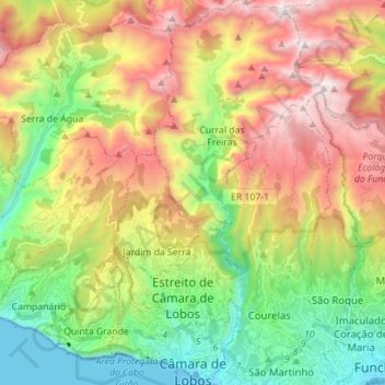
Name: Câmara de Lobos topographic map, elevation, terrain.
Location: Câmara de Lobos, Madeira, Portugal (32.64431 -17.03076 32.76236 -16.92868)
Average elevation: 2,562 ft
Minimum elevation: 0 ft
Maximum elevation: 6,017 ft
Câmara de Lobos is the second largest settlement by population in Madeira with the largest (45%) contribution of youth under 25 years. Located within the metropolitan zone of Funchal, it is limited to the east by Funchal (through the parish of Estreito de Câmara de Lobos); to the west by the municipality of Ribeira Brava and the steep cliffs of Cabo Girão (one of the highest cliffs in Europe: 580 meter elevation); and north by the municipalities of Santana and São Vicente (and the mountains of Pico de Arieiro); while fronting the Atlantic Ocean to the south (except an area in the southwest near Quinta Grande (Fajã dos Padres) whose coast is part of the neighbouring parish of Campanário in Ribeira Brava
Other topographic maps
Click on a map to view its topography, its elevation and its terrain.
Lisbon
Portugal > Área Metropolitana de Lisboa > Lisbon
Benfica, Lisbon, Grande Lisboa, Área Metropolitana de Lisboa, Portugal
Average elevation: 361 ft
Alto do Moinho
Portugal > Setúbal > Seixal > Corroios
Alto do Moinho, Corroios, Seixal, Setúbal, 2855-719, Portugal
Average elevation: 118 ft
Carvalheda
Portugal > Aveiro > Vale de Cambra > Roge
Carvalheda, Roge, Vale de Cambra, Aveiro, 3730-384, Portugal
Average elevation: 2,096 ft
Maçãs de Dona Maria
Maçãs de Dona Maria, Alvaiázere, Leiria, Portugal
Average elevation: 945 ft
Facho
Portugal > Braga > Vila Nova de Famalicão
Facho, Vila Nova de Famalicão, Braga, 4760-484, Portugal
Average elevation: 495 ft
Cascata da Ermida
Portugal > Viana do Castelo > Ponte da Barca
Cascata da Ermida, Entre Ambos-os-Rios, Ermida e Germil, Ponte da Barca, Viana do Castelo, 4980-330, Portugal
Average elevation: 1,831 ft
Vilar de Suente
Portugal > Viana do Castelo > Soajo
Vilar de Suente, Soajo, Arcos de Valdevez, Viana do Castelo, 4970-672, Portugal
Average elevation: 1,552 ft
Pessegueiro do Vouga
Portugal > Aveiro > Sever do Vouga
Pessegueiro do Vouga, Sever do Vouga, Aveiro, Portugal
Average elevation: 617 ft
Travanca de Lagos
Travanca de Lagos, Oliveira do Hospital, Coimbra, Portugal
Average elevation: 1,188 ft
Medelim
Portugal > Castelo Branco > Idanha-a-Nova
Medelim, Idanha-a-Nova, Castelo Branco, Portugal
Average elevation: 1,296 ft
Abade de Neiva
Abade de Neiva, Barcelos, Braga, Portugal
Average elevation: 358 ft
Vale Covo
Portugal > Leiria > Bombarral e Vale Covo
Vale Covo, Bombarral e Vale Covo, Bombarral, Leiria, 2540-069, Portugal
Average elevation: 233 ft
Idanha-a-Nova
Idanha-a-Nova, Castelo Branco, Portugal
Average elevation: 1,053 ft
Veade
Portugal > Braga > Celorico de Basto
Veade, Celorico de Basto, Braga, 4880-195, Portugal
Average elevation: 699 ft
Pampilhosa da Serra
Pampilhosa da Serra, Coimbra, Portugal
Average elevation: 1,926 ft
Cerqueda
Portugal > Aveiro > Vale de Cambra
Cerqueda, Vila Chã, Codal e Vila Cova de Perrinho, Vale de Cambra, Aveiro, 3730-135, Portugal
Average elevation: 1,083 ft
Afurada
Portugal > Porto > Vila Nova de Gaia
Afurada, Vila Nova de Gaia, Porto, 4400-587, Portugal
Average elevation: 161 ft
Vila da Rua
Portugal > Viseu > Moimenta da Beira
Vila da Rua, Moimenta da Beira, Viseu, Portugal
Average elevation: 2,090 ft
Malpica do Tejo
Malpica do Tejo, Castelo Branco, 6000-560, Portugal
Average elevation: 801 ft
Figueira de Castelo Rodrigo
Figueira de Castelo Rodrigo, Guarda, Portugal
Average elevation: 1,762 ft