
Dundalk topographic map
Click on the map to display elevation.
Dundalk
Most of Dundalk is flat and very near sea level, with a few small hills close to the city of Baltimore to the west. Dundalk is part of the Atlantic Coastal Plain. Elevations range from sea level on the shore of the Chesapeake Bay to approximately 40 feet (12 m) above sea level along the northern reaches of Dundalk Avenue and North Point Boulevard.
About this map
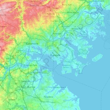
Name: Dundalk topographic map, elevation, terrain.
Location: Dundalk, Baltimore County, Maryland, 21222, United States (39.09741 -76.68367 39.41741 -76.36367)
Average elevation: 108 ft
Minimum elevation: -10 ft
Maximum elevation: 568 ft
Baltimore County trails, hiking, mountain biking, running and outdoor activities
Other topographic maps
Click on a map to view its topography, its elevation and its terrain.
Bowleys Quarters
United States > Maryland > Baltimore County > Bowleys Quarters
Average elevation: 7 ft
Soldiers Delight Natural Environment Area
United States > Maryland > Baltimore County > Owings Mills
Average elevation: 614 ft