
Make a donation
Gear up for your next adventure:
As an Amazon Associate, this site earns from qualifying purchases at no extra cost to you.
Kettleman City topographic map
Click on the map to display elevation.
Make a donation
Gear up for your next adventure:
As an Amazon Associate, this site earns from qualifying purchases at no extra cost to you.
Kettleman City
Kettleman City is a census-designated place (CDP) in Kings County, California, United States. Kettleman City is located 28 miles (45 km) southwest of Hanford, 54 miles (88 km) south of Fresno, at an elevation of 253 feet (77 m), and sits only about 1/2 mile north of the 36th parallel north latitude. It is part of the Hanford-Corcoran Metropolitan Statistical Area. The population was 1,242 at the 2020 census, down from 1,439 at the 2010 census. When travelling between Los Angeles and either San Francisco or Sacramento via Interstate 5, Kettleman City (at Exit 309) is near the halfway point, and is thus a major stopping point for food and lodging.
Make a donation
Gear up for your next adventure:
As an Amazon Associate, this site earns from qualifying purchases at no extra cost to you.
About this map
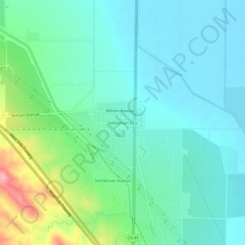
Name: Kettleman City topographic map, elevation, terrain.
Average elevation: 289 ft
Minimum elevation: 184 ft
Maximum elevation: 630 ft
Kings County trails, hiking, mountain biking, running and outdoor activities
Make a donation
Gear up for your next adventure:
As an Amazon Associate, this site earns from qualifying purchases at no extra cost to you.
Other topographic maps
Click on a map to view its topography, its elevation and its terrain.
Stratford
United States > California > Kings County
Stratford (formerly, Stratton) is a census-designated place (CDP) in Kings County, California, United States. Stratford is located 14 miles (23 km) southwest of Hanford, at an elevation of 203 feet (62 m). It is part of the Hanford–Lemoore Metropolitan Statistical Area. The population was 1,277 at the 2010…
Average elevation: 194 ft
Avenal
United States > California > Kings County
Avenal (Spanish for "Oat field") is a city in Kings County, California, United States. Avenal is located 35 miles (56 km) southwest of Hanford, at an elevation of 807 ft (246 m). It is part of the Hanford–Corcoran Metropolitan Statistical Area (MSA Code 25260), which encompasses all of Kings County. In area,…
Average elevation: 810 ft
Kettleman City
United States > California > Kings County
Kettleman City is a census-designated place (CDP) in Kings County, California, United States. Kettleman City is located 28 miles (45 km) southwest of Hanford, 54 miles (88 km) south of Fresno, at an elevation of 253 feet (77 m), and sits only about 1/2 mile north of the 36th parallel north latitude. It is part…
Average elevation: 276 ft
Make a donation
Gear up for your next adventure:
As an Amazon Associate, this site earns from qualifying purchases at no extra cost to you.