Geolocate

Copeland topographic map

Click on the map to display elevation.

About this map

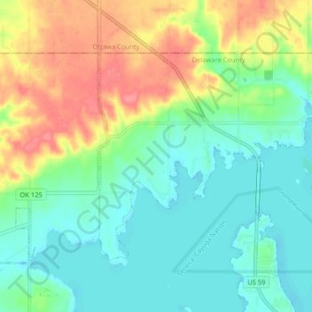
Name: Copeland topographic map, elevation, terrain.

Location: Copeland, Delaware County, Oklahoma, United States (36.62764 -94.85559 36.67061 -94.77511)

Average elevation: 817 ft

Minimum elevation: 738 ft

Maximum elevation: 965 ft

Delaware County trails, hiking, mountain biking, running and outdoor activities

Other topographic maps

Click on a map to view its topography, its elevation and its terrain.

Chloeta

United States > Oklahoma > Delaware County

Average elevation: 863 ft

Eucha

United States > Oklahoma > Delaware County

Average elevation: 1,024 ft

Kenwood

United States > Oklahoma > Delaware County

Average elevation: 866 ft

Gear up for your next adventure:

GPS Sports Watch - GPS watch for running, hiking and training
🥇GPS Hiking Watch - Multi‑sport GPS watch with navigation and trail tracking
💧Water Filtration Bottles - Safely drink from streams and lakes while exploring
🧯Emergency Survival Kit - All‑in‑one survival essentials for the backcountry
🧣Merino Neck Gaiters - Multi-functional headwear for wind and sun protection

As an Amazon Associate, this site earns from qualifying purchases at no extra cost to you.