Geolocate

Santa Isabel topographic map

Click on the map to display elevation.

About this map

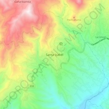
Name: Santa Isabel topographic map, elevation, terrain.

Location: Santa Isabel, Santa Isabel (Chaguarurco), Santa Isabel, Azuay, Ecuador (-3.31418 -79.35516 -3.23418 -79.27516)

Average elevation: 5,098 ft

Minimum elevation: 3,317 ft

Maximum elevation: 7,884 ft

Other topographic maps

Click on a map to view its topography, its elevation and its terrain.

El Carmen de Pijili

Ecuador > Azuay > Santa Isabel

Average elevation: 3,350 ft

Abdon Calderon (La Union)

Ecuador > Azuay > Santa Isabel

Average elevation: 5,587 ft

Gear up for your next adventure:

Camping Coffee Makers - Enjoy premium coffee at the summit or campsite
📦Gear Storage Bags - Organize and protect outdoor equipment
🔭Compact Binoculars - HD vision for scouting terrain and identifying distant landmarks
🪶Trail Camera - Capture wildlife on your hikes
🔥Fast-Boil Camping Stoves - Efficient cooking systems for quick trail meals

As an Amazon Associate, this site earns from qualifying purchases at no extra cost to you.