
Bosna topographic map
Click on the map to display elevation.
About this map
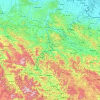
Name: Bosna topographic map, elevation, terrain.
Average elevation: 1,893 ft
Minimum elevation: 249 ft
Maximum elevation: 6,837 ft
Other topographic maps
Click on a map to view its topography, its elevation and its terrain.
Sarajevo
Bosnia and Herzegovina > Federation of Bosnia and Herzegovina > Sarajevo
Average elevation: 3,117 ft
Jablanica
Bosnia and Herzegovina > Federation of Bosnia and Herzegovina
The mean elevation of Jablanica is 202 metres (663 ft) above sea level. Some 69% of the municipalities 301 km2 (116 sq mi) of area is forested. The Jablanica lake is an important geographical as well as economic presence in Jablanica.
Average elevation: 1,535 ft
Rama
Bosnia and Herzegovina > Federation of Bosnia and Herzegovina > Gračanica
Average elevation: 2,385 ft
Mostar
Bosnia and Herzegovina > Federation of Bosnia and Herzegovina > City of Mostar
Average elevation: 1,975 ft
Tuzla
Bosnia and Herzegovina > Federation of Bosnia and Herzegovina > City of Tuzla
Average elevation: 1,145 ft
Zenica
Bosnia and Herzegovina > Federation of Bosnia and Herzegovina > City of Zenica
The city is geographically located in the heart of Bosnia. The settled area is 43.01 km2 (16.61 sq mi) and of the city proper covers 558.5 km2 (215.6 sq mi). Elevation is 310–350 m (1,017–1,148 ft). The rivers Bosna, Lašva, Babina, and Kočeva flow through the settlement. A moderate continental climate…
Average elevation: 2,395 ft
Novi Travnik
Bosnia and Herzegovina > Federation of Bosnia and Herzegovina > Novi Travnik
Average elevation: 2,264 ft
Srebrenik
Bosnia and Herzegovina > Federation of Bosnia and Herzegovina > Town of Srebrenik > Srebrenik
Average elevation: 948 ft
Gračanica
Bosnia and Herzegovina > Federation of Bosnia and Herzegovina > Town of Gračanica > Gračanica
Average elevation: 876 ft
Boračko jezero
Bosnia and Herzegovina > Federation of Bosnia and Herzegovina > Town of Konjic > Jezero
It lies at the northeastern foot of the mountain Prenj, at an altitude 397 m. From the west it is surrounded by steep forested mountain slopes of Crna Gora (Black Mountain, 1343 m), and from the east by Tranjine (1055 m). The lake basin was created in the Boračka draga, during the expansive process of glacial…
Average elevation: 2,185 ft
Čapljina
Bosnia and Herzegovina > Federation of Bosnia and Herzegovina > City of Čapljina
Average elevation: 322 ft
Velež
Bosnia and Herzegovina > Federation of Bosnia and Herzegovina > Town of Zavidovići
Average elevation: 1,759 ft
Lukavac
Bosnia and Herzegovina > Federation of Bosnia and Herzegovina > Town of Lukavac
Average elevation: 728 ft
Žitomislići
Bosnia and Herzegovina > Federation of Bosnia and Herzegovina > City of Mostar
Average elevation: 630 ft
Široki Brijeg
Bosnia and Herzegovina > Federation of Bosnia and Herzegovina > City of Široki Brijeg
Neogenic layers are built of marl, sandy clay, sandstone and conglomerates, and can be found in the vicinity of Grabovo Drage and Mostarsko Blato. Quaternary banks of pebbles, sand and water karst saturated found on almost all rocky fields and drifts along the river beds. Between the lower mountain Vardi,…
Average elevation: 1,329 ft
Pribava
Bosnia and Herzegovina > Federation of Bosnia and Herzegovina > Town of Gračanica > Pribava
Average elevation: 682 ft
Lom
Bosnia and Herzegovina > Federation of Bosnia and Herzegovina > Stari Teočak
Average elevation: 1,644 ft