Geolocate

Anandnagar topographic map

Click on the map to display elevation.

About this map

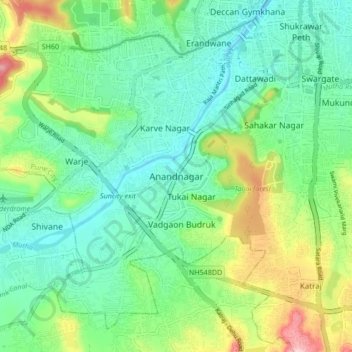
Name: Anandnagar topographic map, elevation, terrain.

Location: Anandnagar, Pune, Pune District, Maharashtra, 411051, India (18.43842 73.78408 18.51842 73.86408)

Average elevation: 1,972 ft

Minimum elevation: 1,778 ft

Maximum elevation: 2,441 ft

Other topographic maps

Click on a map to view its topography, its elevation and its terrain.

Mula-Mutha River

India > Maharashtra > Pune > Khadki

Average elevation: 1,824 ft

Magarpatta City School Ground

India > Maharashtra > Pune

Average elevation: 1,864 ft

Indrayani

India > Maharashtra > Pune

Average elevation: 2,224 ft

Kamala Nehru Park

India > Maharashtra > Pune

Average elevation: 1,893 ft

Udaan Biodiversity Park

India > Maharashtra > Pune

Average elevation: 1,877 ft

Katraj Lake

India > Maharashtra > Pune > Katraj

Average elevation: 2,172 ft

Chittranjan Vatika

India > Maharashtra > Pune

Average elevation: 1,883 ft

Gear up for your next adventure:

🧥Men's Rain Shells - Premium waterproof and breathable jackets for mountain weather
🪶Compact Camp Shovel - Folding shovel for campsite tasks
Backpacking Tents - Weight-optimized shelters for multi-day topographic surveys
GPS Sports Watch - GPS watch for running, hiking and training
👟Trail Running Shoes - Lightweight shoes for trail runners

As an Amazon Associate, this site earns from qualifying purchases at no extra cost to you.