Geolocate

Whitehaven topographic map

Click on the map to display elevation.

About this map

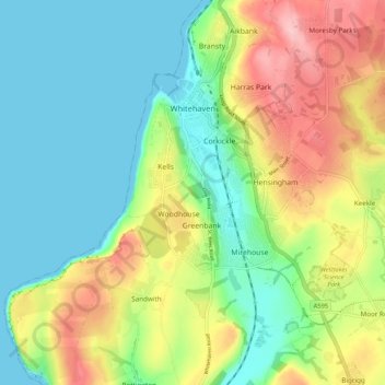
Name: Whitehaven topographic map, elevation, terrain.

Location: Whitehaven, Cumberland, England, United Kingdom (54.50313 -3.61523 54.56479 -3.54452)

Average elevation: 194 ft

Minimum elevation: 0 ft

Maximum elevation: 538 ft

Other topographic maps

Click on a map to view its topography, its elevation and its terrain.

Cat Bells

United Kingdom > England > Cumberland > Stair

Average elevation: 597 ft

Braithwaite

United Kingdom > England > Cumberland

Average elevation: 577 ft

Legburthwaite

United Kingdom > England > Cumberland

Average elevation: 1,286 ft

The Green

United Kingdom > England > Cumberland

Average elevation: 210 ft

Bridgefoot

United Kingdom > England > Cumberland

Average elevation: 213 ft

Drumburgh

United Kingdom > England > Cumberland

Average elevation: 20 ft

Gear up for your next adventure:

🧷Carabiner Set - Durable clips for gear attachment
Camping Coffee Makers - Enjoy premium coffee at the summit or campsite
📚USA Hiking Guide Books - Top trail guides and map books
🪶Compact Camp Shovel - Folding shovel for campsite tasks
🔥Camping Stove - Portable stove for camping and backcountry cooking

As an Amazon Associate, this site earns from qualifying purchases at no extra cost to you.