Geolocate

Braithwaite topographic map

Click on the map to display elevation.

About this map

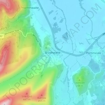
Name: Braithwaite topographic map, elevation, terrain.

Location: Braithwaite, Cumberland, England, CA12 5TJ, United Kingdom (54.58190 -3.21032 54.62190 -3.17032)

Average elevation: 577 ft

Minimum elevation: 230 ft

Maximum elevation: 1,818 ft

Other topographic maps

Click on a map to view its topography, its elevation and its terrain.

Arthuret

United Kingdom > England > Cumberland

Average elevation: 171 ft

Emerald Pools

United Kingdom > England > Cumberland

Average elevation: 1,716 ft

Penrith

United Kingdom > England > Cumberland

Average elevation: 531 ft

Whitehaven

United Kingdom > England > Cumberland

Average elevation: 194 ft

Gear up for your next adventure:

🔪Outdoor Multitools - Essential survival tools for gear repair and field use
🪶Fire Starter Kit - Reliable fire starter for survival and camping
🪑Portable Camp Table - Compact table for campsite meals
📻Weather Alert Radios - Stay informed of storm risks while off-the-grid
🧤Tactile Hiking Gloves - Keep hands warm while operating GPS and smartphone screens

As an Amazon Associate, this site earns from qualifying purchases at no extra cost to you.