
Chilliwack topographic map
Click on the map to display elevation.
About this map
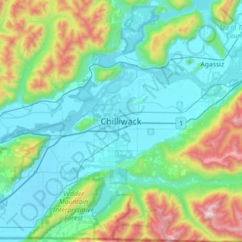
Name: Chilliwack topographic map, elevation, terrain.
Average elevation: 1,286 ft
Minimum elevation: -3 ft
Maximum elevation: 6,529 ft
Other topographic maps
Click on a map to view its topography, its elevation and its terrain.
Fraser River
Canada > British Columbia > Fraser Valley Regional District > Chilliwack > Minto Landing
Average elevation: 328 ft
Calkins Creek
Canada > British Columbia > Fraser Valley Regional District > Chilliwack
Average elevation: 335 ft