
Make a donation
Gear up for your next adventure:
As an Amazon Associate, this site earns from qualifying purchases at no extra cost to you.
Siedlung Determeyer topographic map
Click on the map to display elevation.
Make a donation
Gear up for your next adventure:
As an Amazon Associate, this site earns from qualifying purchases at no extra cost to you.
About this map
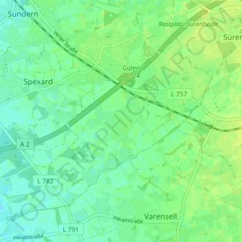
Name: Siedlung Determeyer topographic map, elevation, terrain.
Average elevation: 272 ft
Minimum elevation: 249 ft
Maximum elevation: 292 ft
Make a donation
Gear up for your next adventure:
As an Amazon Associate, this site earns from qualifying purchases at no extra cost to you.
Other topographic maps
Click on a map to view its topography, its elevation and its terrain.
Friedrichsdorf
Deutschland > Nordrhein-Westfalen > Kreis Gütersloh > Gütersloh
Geografisch liegt Friedrichsdorf am Ostrand der westfälischen Bucht südwestlich des Teutoburger Waldes auf einer Höhe von 100 m ü. NN. Angrenzende Orte sind nord und nordöstlich die Bielefelder Stadtteile Senne, Ummeln und Brackwede sowie südwestlich der ebenfalls zu Gütersloh gehörende Ort Avenwedde.…
Average elevation: 335 ft
Avenwedde
Deutschland > Nordrhein-Westfalen > Kreis Gütersloh > Gütersloh
Avenwedde liegt auf einer Höhe von 89 m ü. NHN und umfasst eine Fläche von 21,64 km².
Average elevation: 292 ft