
Frisco topographic map
Click on the map to display elevation.
Frisco
In 1902, a line of the St. Louis-San Francisco Railway was being built through the area, and periodic watering stops were needed along the route for the steam locomotives. The current settlement of Lebanon was on the Preston Ridge, and was too high in elevation, so the watering stop was placed about 4 miles (6 km) to the west on lower ground. A community grew around this train stop. Some Lebanon residents moved their houses to the new community on logs. The new town was originally named Emerson, but the U.S. Postal Service rejected the name as too similar to another community, Emberson, in Lamar County.
About this map
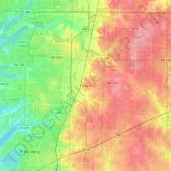
Name: Frisco topographic map, elevation, terrain.
Location: Frisco, Collin County, Texas, United States (33.08110 -96.92279 33.21958 -96.73277)
Average elevation: 659 ft
Minimum elevation: 499 ft
Maximum elevation: 810 ft
Collin County trails, hiking, mountain biking, running and outdoor activities
Other topographic maps
Click on a map to view its topography, its elevation and its terrain.
Frisco
United States > Texas > Collin County > Frisco
When the Dallas area was being settled by American pioneers, many of the settlers traveled by wagon trains along the Shawnee Trail. This trail became the Preston Trail, and later, Preston Road. With all of this activity, the community of Lebanon was founded along this trail, and was granted a U.S. post office…
Average elevation: 627 ft
Plano
United States > Texas > Collin County > Plano
At first, Plano's population grew slowly, reaching 1,304 in 1900 and 3,695 in 1960. By 1970, Plano began to feel some of the boom its neighbors had experienced after World War II. A series of public works projects and a change in taxes that removed the farming community from the town helped increase the…
Average elevation: 594 ft
Lavon Beach Estates
United States > Texas > Collin County > Lavon Beach Estates
Average elevation: 505 ft