
Altoga topographic map
Click on the map to display elevation.
About this map
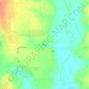
Name: Altoga topographic map, elevation, terrain.
Location: Altoga, Collin County, Texas, United States (33.22984 -96.50943 33.26984 -96.46943)
Average elevation: 577 ft
Minimum elevation: 512 ft
Maximum elevation: 673 ft
Other topographic maps
Click on a map to view its topography, its elevation and its terrain.
Frisco
United States > Texas > Collin County
In 1902, a line of the St. Louis-San Francisco Railway was being built through the area, and periodic watering stops were needed along the route for the steam locomotives. The current settlement of Lebanon was on the Preston Ridge, and was too high in elevation, so the watering stop was placed about 4 miles (6…
Average elevation: 659 ft
Plano
United States > Texas > Collin County
At first, Plano's population grew slowly, reaching 1,304 in 1900 and 3,695 in 1960. By 1970, Plano began to feel some of the boom its neighbors had experienced after World War II. A series of public works projects and a change in taxes that removed the farming community from the town helped increase the…
Average elevation: 643 ft
Frisco
United States > Texas > Collin County
In 1902, a line of the St. Louis–San Francisco Railway ("the Frisco") was being built through the area, and periodic watering stops were needed along the route for the steam locomotives. The current settlement of Lebanon was on Preston Ridge and was too high in elevation, so the watering stop was placed…
Average elevation: 659 ft
Plano
United States > Texas > Collin County
At first, Plano's population grew slowly, reaching 1,304 in 1900 and 3,695 in 1960. By 1970, Plano began to feel some of the boom its neighbors had experienced after World War II. A series of public works projects and a change in taxes that removed the farming community from the town helped increase the…
Average elevation: 643 ft