
Make a donation
Gear up for your next adventure:
As an Amazon Associate, this site earns from qualifying purchases at no extra cost to you.
Richards Bay topographic map
Click on the map to display elevation.
Make a donation
Gear up for your next adventure:
As an Amazon Associate, this site earns from qualifying purchases at no extra cost to you.
About this map
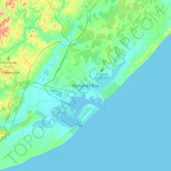
Name: Richards Bay topographic map, elevation, terrain.
Average elevation: 102 ft
Minimum elevation: -3 ft
Maximum elevation: 817 ft
Make a donation
Gear up for your next adventure:
As an Amazon Associate, this site earns from qualifying purchases at no extra cost to you.
Other topographic maps
Click on a map to view its topography, its elevation and its terrain.
Umfolozi River
South Africa > KwaZulu-Natal > King Cetswayo District Municipality
Average elevation: 246 ft
uMhlathuze Local Municipality
South Africa > KwaZulu-Natal > King Cetswayo District Municipality
Average elevation: 167 ft
uMlalazi Local Municipality
South Africa > KwaZulu-Natal > King Cetswayo District Municipality
Average elevation: 1,099 ft
uMhlathuze Local Municipality
South Africa > KwaZulu-Natal > King Cetswayo District Municipality
Average elevation: 167 ft
Make a donation
Gear up for your next adventure:
As an Amazon Associate, this site earns from qualifying purchases at no extra cost to you.
uThukela
South Africa > KwaZulu-Natal > King Cetswayo District Municipality > uMlalazi Local Municipality
The river originates in Mont-aux-Sources of the Drakensberg Mountains at an elevation of almost 11,000 feet and plunges 947 metres down the Tugela Falls. The Mont-aux-Sources is also the origin of tributaries of two other major South African rivers, the Orange and the Caledon River. From the Drakensberg range,…
Average elevation: 781 ft
Richard's Bay Harbour Mangroves
South Africa > KwaZulu-Natal > King Cetswayo District Municipality > Richards Bay
Areas of forest which grow in KwaZulu-Natal, South Africa mostly on south facing slopes in higher rainfall areas, and along the humid coastal areas. Different types of forest can be identified by their species composition which depends mostly on the altitude, latitude and substrate (soil and rock types) in…
Average elevation: 10 ft
uMfolozi Local Municipality
South Africa > KwaZulu-Natal > King Cetswayo District Municipality
Average elevation: 200 ft
uMlalazi Local Municipality
South Africa > KwaZulu-Natal > King Cetswayo District Municipality
Average elevation: 1,099 ft
Make a donation
Gear up for your next adventure:
As an Amazon Associate, this site earns from qualifying purchases at no extra cost to you.