
Make a donation
Gear up for your next adventure:
As an Amazon Associate, this site earns from qualifying purchases at no extra cost to you.
Kalomo topographic map
Click on the map to display elevation.
Make a donation
Gear up for your next adventure:
As an Amazon Associate, this site earns from qualifying purchases at no extra cost to you.
About this map
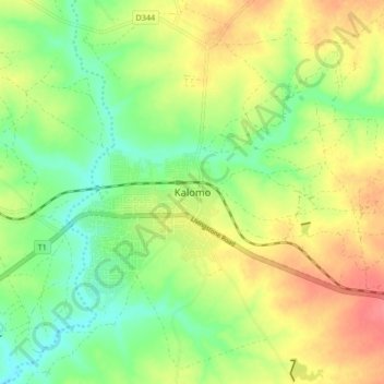
Name: Kalomo topographic map, elevation, terrain.
Location: Kalomo, Kalomo District, Southern Province, Zambia (-17.06371 26.44986 -16.98371 26.52986)
Average elevation: 4,068 ft
Minimum elevation: 3,973 ft
Maximum elevation: 4,183 ft
Make a donation
Gear up for your next adventure:
As an Amazon Associate, this site earns from qualifying purchases at no extra cost to you.
Other topographic maps
Click on a map to view its topography, its elevation and its terrain.
Zambezi
Zambia > Southern Province > Katombora
The river flows to the southwest into Angola for about 240 kilometres (150 mi), then is joined by sizeable tributaries such as the Luena and the Chifumage flowing from highlands to the north-west. It turns south and develops a floodplain, with extreme width variation between the dry and rainy seasons. It…
Average elevation: 3,169 ft